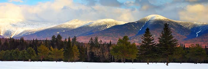


Along Canada’s rugged Pacific coastline, late fall is a subdued season. A steady patter of rain falls on ferns as grizzly bears, bellies full of salmon, den down for winter. As the days grow short, the dense temperate rainforest sinks into a foggy winter torpor.
On a late November morning in 2020, the calm was fractured. It started with a roar, echoing from the mountains above a remote inlet, 130 miles northwest of Vancouver. Rocks destabilized by the retreat of a glacier plummeted down a mountain’s steep slope. Part of a valley wall was collapsing.
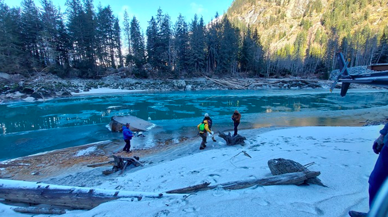
In seconds, 50 million tons of rubble landed in the milky-turquoise waters of Elliot Lake at the glacier’s foot. The landslide’s impact shook the ground with rumbles so deep they were felt by seismometers around the world.
As our world warms, the conditions for glacial lake outburst floods are increasing.
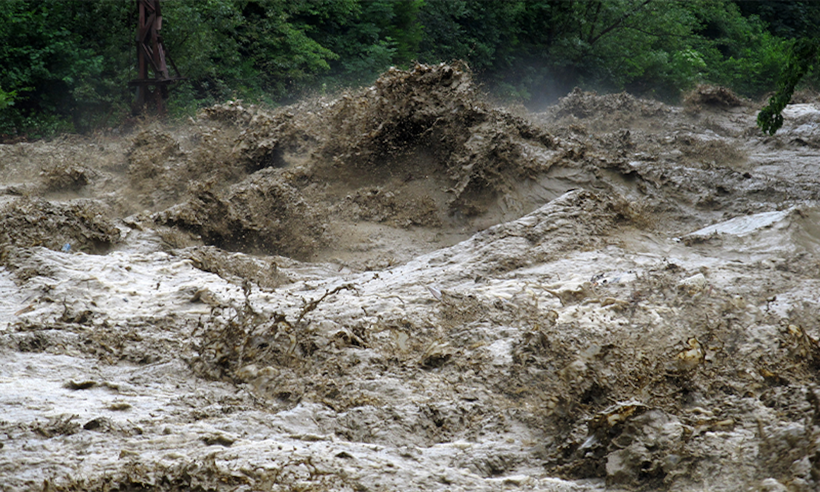
It didn’t end there. The load of rocks that entered Elliot Lake forced up a tsunami over 300 feet tall—high as a skyscraper. The tsunami then blasted down the narrow lake at over 110 miles per hour. The water—enough to fill 5,400 Olympic-sized pools—burst out the far end, scouring a creek bed into a canyon as it descended the mountainside.
The water spared nothing. Giant Douglas fir and western hemlock trees were uprooted as if they were garden weeds. Fridge-sized boulders were tossed like Ping-Pong balls. Sections of the Elliot Creek river channel were dredged 150 feet deep in minutes.
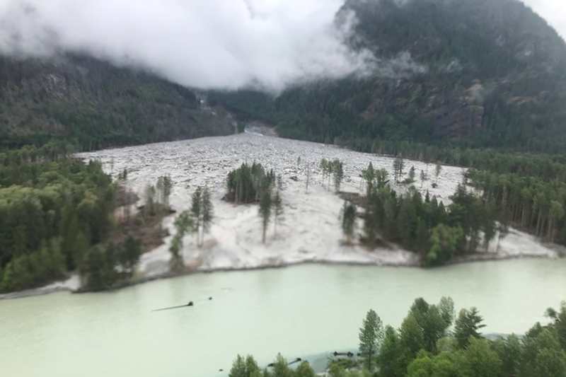
The torrent reached the Southgate River Valley, some 6 miles from Elliot Lake, where it fanned out, bowling over trees and covering a square mile of crucial salmon-spawning habitat in silt and debris up to 16 feet deep. Some material was swept another 5 miles down the Southgate River into the ocean, spilling a plume of cold water and debris so large that it radically changed deep water temperature and chemistry.
Had anybody been in the path of destruction, says University of Northern British Columbia natural hazards specialist Marten Geertsema, “There’s no way you could have escaped.” By the time the bulk of the flood passed into the Southgate River, only about 12 minutes had elapsed. The damage, stretching from mountaintop to seafloor, was only beginning. Two years on, the full impact is still unfolding.
Erik Blaney, Emergency Preparedness and Response Manager for First Nations Emergency Services Society of British Columbia first visited the area of the disaster in 2021. It was just up the coast from where he lives with his family. “It was mind-blowing,” Blaney said. “It’s something that your brain has a hard time comprehending how that even happened.”
It happened because of a rare geological trifecta: landslide, tsunami, flood. Blaney and Geertsema, along with members of the Homalco First Nation, on whose land the event occurred, and a group of geologists, biologists, oceanographers, and researchers detailed the event in a 2022 report in Geophysical Research Letters.1 They identified “rapid glacial retreat” for creating the conditions that allowed the cataclysm to happen.
Technically the event is classified as a glacial lake outburst flood. Occurring in the wake of retreating glaciers, these chain reactions are set up by thousands of years of geology, but strike in just minutes.
Millennia ago, glaciers around the world carved out deep valleys while pushing their bulk through mountain landscapes. Now, as temperatures rise, glaciers are melting and retreating. Glacial lakes can form when the melted water is dammed by leftover ice or material dropped as the glacier withdraws. These lakes are frequently flanked by steep slopes that, once propped up by glacial ice, are now freestanding and unstable. If a large landslide crashes into the lake, the water can rush out in a glacial lake outburst flood.
As our world warms, the conditions for glacial lake outburst floods are increasing. A 2020 Nature Climate Change paper found glacial lakes have increased around 50 percent in number and volume from 1990 to 2018.2 While not all glacial lakes are at high risk to cause catastrophic flooding, the disasters that do happen can claim dozens of lives and cost millions in damages.
A global tally of glacial lake outburst floods compiled in 2016 by Fiona Tweed at Staffordshire University and Jonathan Carrivick of the University of Leeds, found 1,384 events in the past thousand years. Over one third affected communities, including more than 12,500 deaths. And that’s just based on written records. These events “are going to be much more frequent in the future,” Tweed says. “And that is partly because of climate change.”
The triggering events in some glacial lake outburst floods—landslides—are also thought to occur more often in a warming world with more frequent severe weather. A 2022 study of 3,000 landslides in the Austrian Alps published in Communications Earth and Environment found through modeling that 4 degrees Celsius of warming could lead to 45 percent more landslides in the region as heavier rainfall lubricates unstable slopes.3 In mountainous areas, a warmer climate is also projected to reduce alpine permafrost, the long-frozen ground found in high mountain regions, which can further destabilize the ground.
These chain reactions are set up by thousands of years of geology, but strike in just minutes.
Not all researchers agree there’s been an uptick in glacial lake outburst floods yet, but most think that there will be. The current status quo in the frequency of events could be because we’re in a waiting period, suggests Rupert Stuart-Smith, research associate in climate science and law at the Oxford Sustainable Law Programme. It takes time for a glacier to respond to a warming climate, more time for its meltwater to fill a lake, and yet more time before a slope in the right spot above the lake fails.
Lake Palcacocha, a glacial lake in the Peruvian Andes, is an infamous example of a disaster-in-waiting. In 1941, an outburst flood from the lake decimated the city of Huaraz, taking out a third of the town and killing at least 1,800 people. Today, human-induced climate change has increased the lake volume to 34 times its 1941 volume, and the town itself has grown from 11,000 to 120,000 people. Were a similar disaster to occur now, it could have a much larger impact.4 Local officials are working to shore up the lake’s banks and siphon off extra water, but the water levels—and flood risk—keep rising.
Landslides can do plenty of damage, even without glacial lakes. In 2021, a massive rock and glacial ice avalanche 50 percent larger in volume than the Elliot Creek landslide crashed through the Chamoli district of the Indian Himalayas. The debris rushed through a set of valleys, tossing huge boulders, tearing down roads, destroying two hydropower projects, and claiming 200 lives along the way. Later, satellite images showed sediment from the event 560 miles downstream in the Ganges River. It may have gone farther, but that’s as far as scientists could track.
While the floodwaters from the Elliot Creek disaster have receded, the damage is long lasting. Before the flood, the area provided fertile spawning grounds for chum, pink, and coho salmon and cutthroat trout. Now, impacted sections are a barren moonscape of rocks and debris.
Today, the Elliot creek bed is still highly unstable and leeching sediment downstream, where it continues to clog the Southgate River and the gills of fish trying to swim there. Even once the debris and turbidity levels settle, the silty riverbed will no longer be suitable spawning grounds for some species, like chum salmon, who prefer pebbly-bottomed waters. Additionally, the shady canopies that once cooled the riverbanks to fish nursery-friendly temperatures have been washed away.
The Homalco Nation is considering efforts to help redirect the river through the remaining tree stands, but the creek is still too unstable. During an unprecedented heatwave in June 2021, melted snowpack from the surrounding mountains caused the river to dramatically change course at least five times in just three days. While the creek is still settling on its new direction—something that could take years—any efforts to choose a path for the creek could be undone by an extreme rainstorm or heatwave.
Cost is also an issue. “When you start looking at the impacts of this [event], you know, we’re looking in the billions probably [for] restoration,” Blaney says.
Blaney and other researchers from the Homalco Nation, British Columbian government, and the Hakai Institute, a scientific research center based in the area, are monitoring the ongoing changes in the region with temperature, oxygen, and turbidity sensors, and cameras. That information will guide the Homalco Nation in making fish harvest quotas and land use decisions, including logging and mining, Blaney says.
The full impact of the disaster will likely be spread over years as salmon populations—already at historic lows due to overfishing, spawning habitat loss, and climate change—are affected. This will create its own cascade of ecological and economic effects as the decrease in salmon hits local harvesters, including community members, grizzly bears, and tourism operators.
“It’s such a massive event that it’s really hard to count the losses, I guess because they’re not instantly realized,” Blaney says. “I think over the next four or five years when there’s 80 to 90 percent less salmon hitting the plates in the [Homalco] community, that’s when people are going to really realize holy cow, this event had a massive impact on our seafood protein intake.”
Geertsema, Blaney, and others in the Homalco Nation worry this event is the first of many. Across British Columbia, glacial lakes have nearly doubled in volume in the past 30 years. An assessment of glacial lakes in Homalco lands revealed at least four other areas of concern. Researchers have identified 178 Southgate River-like watersheds that could experience similar outburst flood disasters along the British Columbian-Alaskan coast.
If more floods are expected, the question becomes when. In recent years, improved seismometer sensitivity, lidar, and satellite imaging are providing scientists a boost in understanding these events, but predicting a landslide is nearly impossible.
“Predicting where something might happen is the easiest [part],” Geertsema says. “Predicting when it will happen is more difficult.”
Some slides—Elliot Creek and Chamoli included—show a slow creep in the months or years leading up to an event. Others give way without warning, making it hard to provide notice to anyone who might be in harm’s way.
Most of the time, researchers must sift through the debris after the fact like detectives to figure out what happened. But the Elliot Creek disaster occurred in a richly studied area—providing researchers the equivalent of video surveillance of a crime scene.
In recent years, lidar data—a remote sensing technique using lasers that can provide precise 3-D surface mapping—of the Elliot Creek watershed and water samples from Bute Inlet have been collected by a forestry company and the Hakai Institute. Comparing this with similar data collected after the slide, Geertsema and his colleagues had a wealth of information to plug into computer models to map the event’s destructive path from sky to sea.
The researchers’ results show how the landscape changed in incredible detail. In its rush downhill, the flood eroded tens of feet of sediment in some areas and deposited enough to bury a truck in others. Analysis of the water samples showed that upon entering the ocean, the water cooled the inlet depths half a degree Celsius—instantaneously bucking a 70-year trend that has seen 1.3 degrees Celsius warming—and dramatically increased oxygen levels. Even seven weeks after the flood, turbidity levels—which measure how much sediment clouds the water—in the Southgate River were up to 32 times higher at the affected area than they were farther upstream, where the flood didn’t reach.
While the researchers have pieced together the minutiae of what happened, they still don’t know exactly what triggered the initial landslide. The precise cause will likely never be pinpointed, but it’s clear to the researchers that the recent accelerated retreat of the glacier, which had shrunk by some 1.5 miles in the past 50 years, played a crucial role.
With rising global temperatures, those living in the shadows of glaciers will likely see more catastrophes in coming years. But with ongoing monitoring and an increased understanding of glacial lake outburst floods through studies like the one at Elliot Creek, there’s hope future events can be mitigated by improving risk assessments and planning future developments and population centers more mindfully.
“We are in crisis mode,” Blaney says. “We really need to come together to figure this out.” 
Mara Johnson-Groh is a freelance science writer and photographer who writes about everything under the sun, and even things beyond it. Her work has been featured in publications such as Science News, Scientific American, NASA, Discover, and more.
Lead image: Runja / Shutterstock
References
1. Geertsema, M., et al. The 28 November 2020 landslide, tsunami, and outburst flood—a hazard cascade associated with rapid deglaciation at Elliot Creek, British Columbia, Canada. Geophysical Research Letters 49, e2021GL096716 (2022).
2. Shugar, D.H., et al. Rapid worldwide growth of glacial lakes since 1990. Nature Climate Change 10, 939-945 (2020).
3. Maraun, D., et al. A severe landslide event in the Alpine foreland under possible future climate and land-use changes. Nature Communications Earth & Environment 3, 87 (2022).
4. Stuart-Smith, R.F., Roe, G.H.,Li, S., & Allen, M.R. Increased outburst flood hazard from Lake Palcacocha due to human-induced glacier retreat. Nature Geoscience 14, 85-90 (2021).