By middle school, most students have learned that the Amazon River is the mightiest of Earth’s rivers. Its mean discharge to the ocean of about 209,000 cubic meters per second is more than the combined discharges of the next six largest rivers in the world. Its farthest tributaries rise in the Andes a few hundred kilometers from the Pacific Ocean, and it drains an area of about 7 million square kilometers as it crosses South America to the Atlantic. The Amazon dwarfs North America’s largest river system, the Mississippi, which drains less than half the area of the Amazon and discharges about one-tenth as much water.
Earth scientists may pause to wonder why North America does not have a west-to-east-flowing river basin of similar scale to the Amazon, given the similar geologic histories of the two continents: Both North America and South America moved westward with the opening of the Atlantic Ocean, and had comparable interactions with tectonic plates underlying the Pacific Ocean. These interactions resulted in a continuous mountain cordillera along the western margins of both continents, and in each case, drainage from the cordillera flowed east, across sedimentary platforms and Precambrian shields.
In fact, North America did have such an extensive river system.
From about 50 million to 3 million years ago, this system drained an area larger than today’s Amazon before it was supplanted by the continent’s modern river systems during the Pleistocene. In recent years, as details of this former fluvial giant have emerged, it has become known as the Paleo-Bell River in honor of Canadian geologist Robert Bell, who first presented evidence of its existence.
North America’s Amazon Hypothesized
Robert Bell was born in Toronto in 1841, less than a year before the founding of the Geological Survey of Canada (GSC), an organization to which he would devote 50 years of service. He first tasted the adventure of geological exploration as a teenage field assistant to Sir William Logan, who founded the GSC. Following Bell’s university education and several years as a university professor, he joined the GSC and began reconnaissance surveys of the geology, flora, fauna, indigenous peoples and agricultural potential of the vast regions that drained into Hudson Bay.
Each summer, Bell and other GSC scientists disappeared into the northern wilderness of Canada, travelling by boat, canoe or horseback. As only rudimentary maps from exploration and trade routes associated with the fur trade existed for much of this region, field parties commonly made topographic maps as well as geological maps as they proceeded. Illness or injury in the field sometimes resulted in death; a proactive Bell earned a medical degree in 1878 to deal with such eventualities. From 1884 to 1885, he took to the sea as a medical and science officer on research ships exploring the oceanography of Hudson Bay and Hudson Strait, which separates Labrador from Baffin Island and is the bay’s outlet to the Atlantic Ocean.
During their explorations on land and at sea, Bell and his GSC colleagues keenly observed evidence of past glaciations of the landscape. They, in association with the U.S. Geological Survey and university colleagues, eventually outlined the limits of glaciation and compiled evidence of ice flow directions across North America.
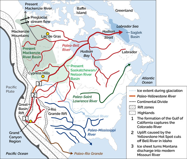
Bell integrated his 25 years of fieldwork and that of fellow GSC explorer-scientists in reconstructing the patterns of drainage that existed prior to glaciation. In May 1895, at the annual meeting of the Royal Society of Canada, he made a bold hypothesis: There had been a great preglacial river basin that drained into a trunk stream that traversed what is now Hudson Bay and exited into the Atlantic Ocean through Hudson Strait. The basin of this river would have extended east from the Canadian Rocky Mountains and from the north central United States to what is now the Mackenzie River Basin—North America’s second largest river basin, which drains into the Arctic Ocean. Bell did not know how and why the relatively shallow Hudson Bay was once above sea level, but his paleo-drainage reconstruction indicated that it had been—and in relatively recent geologic time.
Within a few years, A.W.G. Wilson of McGill University cited extensive evidence that the Canadian Shield, eroded to a nearly flat surface, had been broadly uplifted and warped in geologically recent time. This notion supported Bell’s view that Hudson Bay had been above sea level prior to glaciation. Why this uplift occurred and why the contemporary Hudson Bay lay below sea level were still not known to Bell and Wilson. Despite such knowledge gaps, Bell—like many great scientists before him—had seen the larger picture. And over the next century, his “great preglacial river” was slowly corroborated as geologists investigated North America’s ancient past for a variety of reasons, from seeking oil and gas to searching for diamonds.
Evidence of Bell’s River in the West
Early in the exploration of the American and Canadian west, geologists recognized that an interior seaway once stretched from the Arctic Ocean to the Gulf of Mexico, between the rising cordillera to the west and the Canadian Shield and Appalachian Mountains to the east. The seaway existed during the Late Cretaceous from about 90 million to 70 million years ago. Dinosaurs roamed its forested shores, and the forests shed pollen into the adjacent sea that was buried amid seafloor sediments. This fossil pollen also played a large role as evidence for the existence of the Paleo-Bell River.
By the early Cenozoic Era, about 50 million to 60 million years ago, the seaway had become dry land as erosion of the eastern margin of the young cordillera resulted in the growth of massive alluvial fans that filled the seaway and spread eastward toward the Canadian Shield and what is now Hudson Bay. These fans would have been of comparable scale to the modern delta of the Ganges-Brahmaputra River in Bangladesh and northeastern India, which drains much of the Himalayas today. The erosion of the mountains and growth of the deltas established the west-to-east drainage pattern that gave rise to the Paleo-Bell River system (drainage had been east to west prior to the rise of the cordillera).
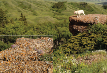
Subsequent regional uplift of the interior plains of North America resulted in the erosion of much of these fan sediments as well as some of the underlying seaway sediments. However, scattered across the interior plains of the northern U.S. and Canada are remnants of some of the earliest deposits laid down by the Paleo-Bell River system. One of the best-known examples is from the Cypress Hills in southwestern Saskatchewan and southeastern Alberta, Canada, about 70 kilometers north of the Montana border. Today, the hills rise about 300 meters above the surrounding plains, but in the past, the summits of this upland area were high enough to rise above the kilometers-thick continental glaciers of the last several million years.
In the 1880s, pioneering geologist R.G. McConnell, a colleague of Bell, noted that the upland was capped by distinctive reddish, quartz-rich gravels. These gravels are largely derived from the Belt Supergroup, a massive assemblage of sedimentary and mafic volcanic rocks deposited about 1.4 billion years ago and which underlie the spectacular mountains of Montana’s Glacier National Park and much of the adjacent Rockies. The nearest outcrops of Belt rocks to the Cypress Hills, however, occur hundreds of kilometers southwest of the hills. These gravels were recognized as having been transported across the braided flood plain of a great river—apparently an ancestor of the Yellowstone River system—that flowed northeastward toward Hudson Bay. Subsequently, fossil mammal remains from between 30 million and 10 million years ago in the Oligocene and Miocene were identified in these gravels. And in a 2013 article in GSA Today, geologist James Sears of the University of Montana concluded that the drainage basin associated with these gravels may at times have extended as far south as what is now the Grand Canyon region. (see below)
Uplands similar in age to the Cypress Hills are found scattered amid the interior plains to north of the Arctic Circle and document other branches of a former vast river system that flowed east toward Hudson Bay from the Eocene through the Pliocene epochs (about 55 million to 3 million years ago). By the start of regional glaciation about 2.6 million years ago, the areas between these uplands were eroded down to about the level of the interior plains and adjacent Canadian Shield today. However, virtual time capsules of Eocene sediments, complete with vegetation, were preserved by volcanism that emplaced diamonds in what is today Canada’s Northwest Territories. Diamond exploration and mining in the Lac de Gras diamond fields, for example, has inadvertently yielded fascinating information about climatic conditions in the Paleo-Bell River Basin tens of millions of years ago (see sidebar below).
Through the Pleistocene, the periodic spread of ice sheets over most of what is now Canada and the northern U.S. eventually disrupted some rivers of the Paleo-Bell system, such as the early Yellowstone River, diverting these flows from their northeastward courses more to the east, into what would become the Missouri River, the path of which largely marks the margin of past ice sheets. Rivers farther north in the Paleo-Bell system, meanwhile, may have re-established their prior routes during intervals between glacial episodes until they assumed their current courses.
The Paleo-Bell’s Mouth Is Discovered
During the 20th century, the search for new sources of oil and gas, and advances in offshore drilling technology, opened up deeper and stormier seas to geologic exploration. By the 1970s, the continental shelves of Labrador and Baffin Island had become prospects for exploration. Drilling and seismic investigations revealed that the area was underlain by millions of cubic kilometers of sediments deposited during and after the opening of the North Atlantic, beginning about 140 million years ago. N.J. McMillan, then with Aquitaine Petroleum in Calgary, compiled existing drilling data and geophysical data for the region and identified a large package of sandy and muddy sediments in the Saglek Basin, which lies beneath the Labrador Sea at the mouth of Hudson Strait. These sediments—totaling an estimated 2.5 million cubic kilometers—were deposited between about 55 million and 5 million years ago.
Erosion of adjacent uplands in Labrador and on Baffin Island during this time was inadequate to account for the vast amount of sedimentary material in the Saglek Basin. McMillan recognized that one of Earth’s largest rivers must have discharged into the Atlantic Ocean during that interval. The area corresponded well with the mouth of Hudson Strait, where Robert Bell had placed the mouth of his great preglacial river. In his landmark paper published by the Canadian Society of Petroleum Geologists in 1973, McMillan revived and expanded on Bell’s earlier hypothesis. McMillan’s hypothesis was subsequently corroborated by research carried out in the 1980s by V. Eileen Williams at the University of British Columbia.
Williams separated and studied fossil pollen grains, called palynomorphs, from drill cores obtained from exploratory oil and gas drilling in the late 1970s and early ‘80s in the Saglek Basin. Although the sediments contained pollen as young as about 5 million years old, there was a significant amount of recycled palynomorphs dating from the Mesozoic Era throughout younger sediments associated with the Paleo-Bell River. Studies of modern rivers, such as the Mississippi and Orinoco, have shown that fossil palynomorphs are commonly eroded from sedimentary rocks and transported thousands of kilometers and redeposited (see sidebar below). In the case of the ancient pollen found in the Saglek Basin, Williams concluded that these palynomorphs had eroded from sediments originally deposited in the former North American Interior Seaway. The age range of the younger palynomorphs constrained the duration over which the preglacial river existed to 40 million to 50 million years. By comparison, the delta of the Amazon River has recently been shown to have been in existence for only about 11.5 million years.
The Paleo-Bell Gives Way to the Mackenzie
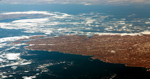
The Pleistocene ice ages, starting about 2.6 million years ago, spelled the end for the Bell River. Ten ice sheets formed over North America during the past million years alone, and many others formed prior to that. The full extent of glacial erosion over Hudson Bay and the Canadian Shield over this period is debated, but the Hudson Bay area likely experienced hundreds of meters of erosion, as well as substantial isostatic depression from the weight of several kilometers of overlying ice (Hudson Bay is still rebounding from unloading of the last ice sheet). As a result, Hudson Bay was inundated by the sea, and rivers began draining directly into it during interglacial periods, cutting off sedimentation to the Saglek Basin.
The Saskatchewan and Nelson river systems, which drain much of Alberta, Saskatchewan and Manitoba, and part of North Dakota, are the last remnants of the Paleo-Bell River system. Ice sheet margins allowed the Mississippi River to capture many formerly northeast-flowing rivers in the American West. However, the grandest change caused by ice sheets was the creation of the Mackenzie River.
The sequence of events that led to the Mackenzie’s formation was largely uncovered through the work of Alejandra Duk-Rodkin, who joined GSC in the early 1980s. At that time, pipelines and oil and gas development were slated for the Mackenzie River Valley and the Mackenzie Delta, and a detailed understanding of the surficial geology was required. Duk-Rodkin began studying and mapping the surficial geology of that region, and of the adjacent Mackenzie Mountains (a northern continuation of the Rockies) and Yukon—an investigation that would last decades.
She found that the Mackenzie Valley region was a palimpsest of two drainage patterns: an older one marked by erosional surfaces that could be traced from the Mackenzie Mountains and Richardson Mountains across what is now the Mackenzie Valley into the interior plains and the Canadian Shield; and a younger pattern that paralleled the Mackenzie Mountains. Additionally, her mapping and stratigraphic work demonstrated that the last Laurentide Ice Sheet was more extensive in that region than any of its predecessors had been over the prior two and a half million years, and that it—spreading westward from northeastern North America—had diverted drainage from the Mackenzie Mountains, from the ice sheet itself, and from as far south as Alberta and British Columbia, to the north. This drainage cut massive canyons leading to the Arctic Ocean.
As the ice sheet later thinned and retreated eastward, it ponded immense lakes in what is now the Mackenzie Valley that eventually spilled northward. The result of all this glacial diversion was the formation of the Mackenzie River Basin, which today covers an area of 1.8 million square kilometers—about the size of Alaska, or about 60 percent of the size of the Mississippi River Basin.
By the early 1990s, Duk-Rodkin realized that the eastward-dipping erosional surfaces crossing the Mackenzie River that she’d observed, indicative of a once mighty pattern of east-directed drainage, were consistent with Bell’s notion of a “great preglacial river.” She simply referred to this former river system as the Bell River. North America’s vanished Amazon had a fitting name.
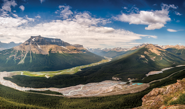
Lead image: The North Saskatchewan River (foreground), at its confluence with the Alexandra River near the rivers’ headwaters in the Canadian Rockies, is part of the Saskatchewan River system, which together with the Nelson River watershed is the last remnant of the once-mighty Paleo-Bell River system. Credit: Yvesgagnon1974/istockphoto.com.
This article was originally published in Earth on July 25, 2018.