“Blow, till thou burst thy wind, if room enough!”
—William Shakespeare, The Tempest, 1610-1611
One Sunday in August 1635, the Mather family from England was finally about to reach the New World when a furious storm caught the ship and its crew by surprise. The cables anchoring the boat near a group of islands, 6 miles off the New England coast, reportedly snapped, and the vessel with its dozens of passengers hurtled toward a rocky shore. Fortunately, the winds turned at the last minute and steered the ship in another direction, their son Increase Mather would later write.
But others weren’t so lucky. According to colony governors in what are now Boston and Plymouth, Massachusetts, the storm drove other ships aground, toppled sundry houses, blew down hundreds of thousands of trees, and caused the sea to swell by up to 20 feet. “[It] was such a mighty storm of wind and rain,” the governor of Plymouth Plantation wrote, “as none living in these parts … ever saw.”
Indeed, contemporary simulations suggest the Great Colonial Hurricane was a Category 3.5 storm, probably the strongest in recorded eastern New England history. (For reference, Sandy, which killed nearly 150 people and caused some $65 billion in damage in the United States, was technically no longer even a hurricane when it made landfall in the New York metro area in 2012.)
Scientists know about the Great Colonial Hurricane’s impact not only from written reports but curiously, also from hidden, physical impressions the long-ago storm left on the landscape.
Hurricanes are not solely random events, but can come in waves across the ages.
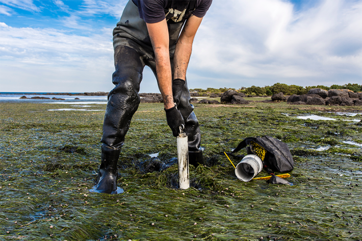
At the bottom of a pond, Jeffrey Donnelly, a hurricane scientist at the Woods Hole Oceanographic Institution, and his colleagues found subtle, buried evidence of the storm that almost felled the Mather line. The researchers were collecting sediment cores from a lakebed on Cape Cod. The spot, known as Salt Pond, lies about a third of a mile from the ocean and has long been a place of mud. But in their core samples, they found a pinky finger-thick layer of pure ocean sand in layers that dated back to roughly 1635. The only thing that could have pulled that much beach material over the sand barrier and that far inland was a truly massive storm.
The cores revealed other clues, too. Although written accounts suggest the 1635 tempest was the strongest of its time, the exhumed samples showed it wasn’t the only intense storm in the area. Donnelly found evidence for 10 major storms1 in the area between 1400 and 1675—a surprising toll, given that major hurricanes are virtually unheard of this far north today. The fact that hurricanes were much more frequent in the past begs the question of why, and whether these levels of storm activity could someday return.
Which is why researchers like Donnelly are traipsing along coastlines and digging in the muck. They hope their relatively new branch of science, paleotempestology (the study of old storms), can use these buried traces of long-gone winds to augur ancient patterns. Patterns that might also help us predict the weather that lies ahead.
Paleotempestology seems like it could be a flighty field, an esoteric subniche of imprecise weather science, borne as it is from shifty grains of sand and mud. But since its birth in the 1990s, it has generated important insights into hurricane activity over centuries and even millennia. And like so many important developments in science, it took off with a seemingly simple question.
During a 1989 lecture, Kam-biu Liu, a scientist at Louisiana State University, was explaining how ash layers marked the activity of ancient volcanoes, when one of his students, Miriam Fearn, asked if hurricanes also left behind detectable traces. This was a possibility he hadn’t considered before.
That summer, they tested the idea at Lake Shelby, a placid freshwater lake near Alabama’s coast. “I still remember vividly the excitement we experienced when we pulled up our first cores from Lake Shelby and we found a distinct sand layer at the top, which was undoubtedly attributed to Hurricane Frederic of 1979,” Liu recounts.
In the following years, Liu collected cores from along the Gulf of Mexico coast and various sites around the Caribbean. Meanwhile, Donnelly and others were producing cores from other places around the world, including the Northeastern U.S. and from large marine caverns called blue holes in the Bahamas. Virtually all of them revealed an undeniable pattern: mundane sediment punctuated by layers of sand—some obvious, but many so faint they require close analysis of the grain sizes—which mark the surges of dramatic storms that blew through long ago.
These ancient depository records are generating a far different picture of storm patterns than instrumental records alone, which only go back 170 years—or even written records, which, in the U.S. trace only a few centuries. A proverbial eye-blink in the history of larger climate and weather patterns.
One nearly 60-foot-long core from a blue hole in the western Bahamas revealed 16 hurricanes between 1850 and 20162—equivalent to 10 hurricanes per century—but nearly three times as many hurricanes per century from not-too-distant times, including 1570-1620. “We already think about this area as being pretty active,” says marine geologist Tyler Winkler, who also conducts research at Woods Hole Oceanographic Institution. “But the fact that that has tripled at times in the past is pretty remarkable and has definite implications for how susceptible this region is to storm activity.”
In this way, paleotempestology data can provide a truly long-term assessment of an area’s risk for a major hurricane strike. That’s why reinsurance companies have long shown interest in paleotempestology research, even funding some of Liu’s early research.
Indeed, at many sites in the western Atlantic, it turns out, hurricanes have undergone wild swings, often striking at frequencies that far exceed those in the past couple of centuries. By themselves, the sand layers in individual cores appear random. But paleotempestologists are beginning to find that, for centuries or millennia at a time, hurricane activity from different sites sometimes lines up. This means that hurricanes are not solely random events, but can come in waves across the ages, driven by regional or even global climatic changes. “It implies that the climate system, quite independent of what humans are doing, is able to modulate hurricane activity significantly,” Donnelly says.
The big mystery scientists are trying to solve is why—and what that could mean for us, as humans continue our own runaway experiment with the Earth’s climate.
To find that out, Donnelly and other paleotempestologists are digging deeper.
In a number of cores from around the Atlantic basin, they have discovered a period of heightened hurricane activity in the Atlantic starting around 250 A.D., long before Europeans set foot on the North American continent. Between 250 and 1150 A.D., for instance, Donnelly’s team counted about 20 major storms in the Salt Pond cores, roughly matching a pattern of elevated storm activity in other records from the Gulf of Mexico coast and parts of the Caribbean. What caused this tempestuous outburst across the North Atlantic?
Mundane sediment punctuated by layers of sand mark the surges of dramatic storms that blew through long ago.
Donnelly and others think it may have to do with warming of sea surface temperatures in the Atlantic during this time. That was especially the case3 between 950 and 1250 A.D., a time known as the Medieval Warm Period, during which scientists think a natural uptick in solar radiation drove a slight increase in average global temperatures (a slower and less extensive warming than what humanity’s burning of fossil fuels is causing today). Researchers estimate that sea surface temperatures rose about half a degree above the long-term norm around this time.
This correlation between hurricane activity and temperatures is illuminating because, while climate models largely agree that human-driven climate change will make hurricanes stronger—as warmer waters fuel them with more energy—there is much less certainty on whether more storms are forming to begin with.
The data from the Medieval Warm Period add to existing evidence that rising temperatures on land and in the ocean play a role in increased hurricane formation, notes Jo Muller, a paleotempestologist at Florida Gulf Coast University. Warmer temperatures can generate more disturbance in the atmosphere. The extreme heat rising off the west coast of the African continent—where many Atlantic storms form—for example, can create the kinds of perturbations that can turn into wind-sucking low-pressure systems that act as seeds for hurricanes, which are further fueled by warm ocean waters and a humid atmosphere, she explains.
But temperatures are not the whole story. Another factor in hurricane formation is wind shear—or, rather, its absence. Sudden changes in wind speed and direction can disrupt the upward airflows needed to create a hurricane. “It will just tear a storm apart,” Muller says of wind shear. It’s conceivable that the climate during the Medieval Warm Period produced not only warmer sea temperatures, but also conditions that discouraged wind shear—something that some recent studies suggest.
Paleotempestologists have also probed the Earth for storm patterns during temperature swings in the opposite direction. Around 1400, Earth’s climate entered the Little Ice Age, a period of worldwide cooling—perhaps driven by an uptick in volcanic eruptions and/or reduced solar activity—that lasted until about 1850. Based on the findings from the Medieval Warm period, one might expect hurricane activity to decrease during this time. But paradoxically, records in some places, including at some sites in the north Atlantic such as Salt Pond, show an abrupt increase.1 “This transition between the Medieval Warm Period and the Little Ice Age around 1400 was a pretty big deal for tropical cyclones globally,” says Donnelly, who has even found changes at some sites in the North Pacific. Somehow, “it was capable of dramatically reshuffling hurricane activity on the planet.”
Curiously, in the Atlantic, it’s only the records in the Northeastern U.S. and the Bahamas,4 farther down in the Atlantic, that show more hurricanes making landfall between 1400 and 1675, including the infamous colonial hurricane in 1635. In the Gulf of Mexico and around the Caribbean Sea—south of the Bahamas—hurricane intensity swings from loud to silent around 1400.
The only thing that could have pulled that much material that far inland was a truly massive storm.
Broadly speaking, “records from New England and the Bahamas tend to match each other, and they tend to be very different from records from the Gulf,” says paleotempestologist Elizabeth Wallace of Old Dominion University. This could hint that, without necessarily affecting the number of Atlantic storms, the dominant storm trajectories changed at the start of the Little Ice Age. “One of the things we’re trying to piece together is why that is,” Wallace says.
Sorting out these unexpected historical dynamics could help solve the puzzle of future storm shifts under a warmer climate. Wallace and her colleagues are currently plugging data from sediment cores into computational models to simulate the world climate centuries ago so they can test what kind of climate dynamics could be driving hurricane patterns. One suspected culprit is a weather system known as the Bermuda High.
The Bermuda High is a high-pressure system that’s usually centered in the mid-Atlantic. Weather forecasters know that the High generates steering winds that can determine the trajectory of west-moving storms, acting like a gardener flushing a hose this way or that, Liu says. When the High is weak or lies northeast of its usual position, it will whip storms up around its western edge and sweep them up the Eastern Seaboard, hitting the Bahamas and the eastern U.S. coast. When it’s stronger or lies more south, it sends storms toward the Caribbean and the Gulf of Mexico. It’s feasible that the High weakened around 1400, causing hurricanes that were previously flung toward the Caribbean and Gulf Coast to hit the Bahamas and New England instead, Wallace says.
If scientists can pinpoint that the Bermuda High was driving these patterns—and if they see that its long-term position and strength is changing today—that could help predict whether we might see more or fewer destructive hurricanes rattling up the Eastern Seaboard, Wallace says. “If we don’t understand how natural climate variability impacts storms, it will be very difficult to predict how human-driven climate changes superimposed on top of natural changes will impact storms.”
Since its inception just a few decades ago, paleotempestology has provided insights once thought unknowable: discerning the winds of the past. But the picture it gives us is still somewhat murky.
Sediment cores from coastal areas only record landfalling storms; it might be that the Atlantic had other major periods rife with hurricanes that never touched land. They also only record intense hurricanes, not small storms or ones that made distant landfall. And in many cases, the cores’ resolution is limited; their dating is often only accurate to decades or even centuries—which is one reason why scientists are also exploring other ways to study past storm activity, such as tree rings, which show traces of large flooding events and can provide more accurate dating.
Importantly, the sediment cores are still too few in number and too limited in geographic scope. There’s a dearth of records for the Southeastern U.S., for instance, and major ocean basins such as the Pacific are understudied. “The distribution of good paleotempestology records is still uneven,” Liu says.
But piecing together this deep historical record of these transient—but powerful—storms is important. Identifying the natural forces that shape hurricane activity will hopefully help provide more accurate long-term forecasts for our era. If places like New England were frequently targeted in the past, they could get hit again. And with today’s densely populated coastlines and supercharged hurricanes, the impacts would likely be even more catastrophic than what early colonists witnessed.
To get to that point, there is still lots more digging to be done. Liu currently likens this young field to paleoanthropology, where biologists try to piece together the story of human evolution from piecemeal records over the past few million years—a femur here, a skull fragment there. Paleotempestologists are hopeful that their work can answer big questions relevant to the future of hundreds of millions of people living along the world’s coastlines. The answers likely lie in tiny grains of sand, blown in by storms of the ages, waiting for scientists to uncover them. 
Katarina Zimmer is a science and environmental journalist currently based in Germany.
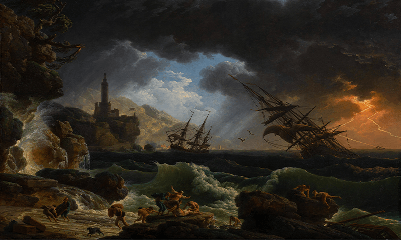
Lead painting by Joseph Vernet / Wikimedia Commons
References
1. Donnelly, J.P., et al. Climate forcing of unprecedented intense-hurricane activity in the last 2,000 years. Earth’s Future 3, 49-65 (2015).
2. Winkler, T.S., et al. Oceanic passage of hurricanes across Cay Sal Bank in the Bahamas over the last 530 years. Marine Geology 443, 106653 (2022).
3. Mann, M.E., Woodruff, J.D., Donnelly, J.P., & Zhang, Z. Atlantic hurricanes and climate over the past 1,500 years. Nature 460, 880-883 (2009).
4. Wallace, E.J., Donnelly, J.P., van Hengstum, P.J., Winkler, T.S., & McKeon, K. 1,050 years of hurricane strikes on Long Island in the Bahamas. Paleoceanography and Paleoclimatology 16 (2021).