Survival shows are running amok. The contestants are naked; they’re two out-of-shape guys in the woods; they’re stuck on an island. Despite differences in attire or setting, one thing remains constant: For every survivor, finding potable water is the first order of business. But the challenge doesn’t end there: First they find water; then they need to bring it home.
This pattern is reflected in the history of all civiliations. From the moment humans discovered the benefit of staying in one spot, growing plants and raising animals, they started to devise ways of bringing water to the settlement. They developed wells and rainwater channels, dug irrigation ditches, and created aqueducts to pull water a long way from its sources. Their engineering paid off; villages, towns, cities flourished; eventually, complex, urban civilizations dominated. It smacked of success.
Except that great solutions to water needs also begat great problems. When water is drawn more quickly than it is replenished naturally, a water source can dry out, endangering people who based their lives around it. Some of our engineered structures, like lead pipes, have led to serious health problems. And when more than one nation draws from a single water source—as in the case of the Jordan River, which feeds into Israel, Jordan, and Syria—tensions can escalate into conflict.
We need water to survive. But the ways we get it have changed our ways of life, driven us from our homelands, and in some cases, poisoned those who’ve stayed. Here are some examples of problems we’ve created by being too good at what we do: surviving.
Just Deserts
NASA’s Terra satellite captured the swift retreat of the Aral Sea from 2000 to 2014.
A sliver here, a spot there. That’s all the water that’s left of the great Aral Sea, once the fourth largest lake in the world by surface area. Recent images of the dry Aral Sea show camels sheltering from the sun beside the rusting husks of fishing boats, perched permanently on the dried-up lakebed. The extreme transformation took all of 50 years.
The Aral Sea wasn’t historically fragile. Humans have been using the saltwater lake for at least 3,000 years, the water level only fluctuating by about four meters during the 300 years prior to 1960. And the water provided for neighboring communities, offering a sustainable and profitable way of life for early 20th-century fishermen who caught carp, pike, and perch in numbers great enough to export them widely. Fish were so abundant that Aralsk fishermen, when called upon by Soviet leader Lenin, were able to load up 14 train cars bound for starved regions of the Soviet Union with fresh Aral Sea fish in October of 1921.
Around 1960 the land began to change. The erstwhile Soviet Union expanded irrigation projects aimed at increasing the yield of profitable cotton. The crop’s thirst for the freshwater in the rivers replenishing the Aral Sea meant less water ended up in the lake. Over time, one of the rivers—the Amu Darya—stopped making it to the lake. And as the water depleted, the salt in the lake’s water became more concentrated. Salinity went up, killing off several fish species that couldn’t cope in the changing environment. Now the fishermen can’t make a living, and those not impoverished by decreasing opportunities in the barren land can only find continuous work in feeding, growing, and picking cotton or other water-guzzling crops. The dry basin itself, doused with farming chemicals and prone to rise up in dust storms, threatens the health of any who live nearby. And since Uzbekistan is today the second-biggest cotton exporter in the world, the Aral Sea has little hope of recovering its former size.
Mad Saddam’s Sad Legacy
The Terra satellite imaged changing terrain in Iraq’s marshes between 2000 and 2010.
Half a million people recently lived in the lush landscape of southern Iraq, full of cane reeds, muddy water, and buffalo. The Ma’dan, or Marsh Arabs, built their homes from stalks of reeds, called qubbara, and grass-like sedge, and set them right in the midst of the marsh, on small islands. They made a living by raising buffaloes. But in the 1990s, there was an exodus from the once fourth largest wetland in the world. The Marsh Arabs dispersed, heading to refugee camps in Iran or other locations in Iraq, trying to make a living in unfamiliar ways, when for 5,000 years, they were used to homes made of products of the marshland. They had to leave because their water was disappearing.
Saddam Hussein had demanded drainage of the water to take revenge on the Ma’dan for their involvement in anti-government rebellions. And due to damming projects upstream, on both the Tigris and Euphrates rivers, and the diversion of water for various other projects, the waters that flooded the southern area of Iraq started to dissipate. The Mesopotamian marshes once stretched over 7,000 square miles. Hundreds of thousands of people and millions of birds, including 278 different species, relied on the nutrient-rich water. But when precipitation was not enough to cover the losses during the Hussein regime, the marshes shrank to approximately 10 percent of their former size.
Although the marshland is today vastly smaller, there have been a few projects implemented that have offered viable solutions for recovering marshland. Azzam Alwash, an Iraq-born engineer, has spearheaded a project for rebuilding the marshland since 2003. He helped develop other structures that prevented water from passing through and paid for an excavator to help marsh Arabs break down embankments. Within six months, the vegetation began to regrow and birds began to return to the area during their migration. Although the marsh hasn’t returned to its former size, the area is beginning to recover and function as it once did, to the benefit of humans and other creatures alike.
Destruction Deferred
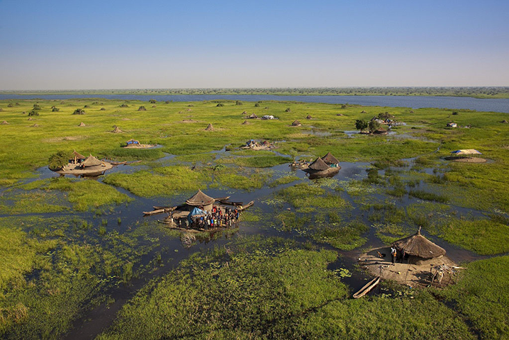
In South Sudan sits a lush wetland, fed by the waters of the White Nile, that hosts many human communities and unusual local habitats. For thousands of years, the water has been used as an oasis—a migratory stop for various birds, a watering hole for large mammals trekking the dry land, and as a means of livelihood for those from nearby villages. But authorities in neighboring regions see the marshland as an available resource, a place where water can be diverted to grow their own communities.
In the late 1970s, Egypt and Sudan agreed to construct the Jonglei Canal, which would stretch over 200 miles and divert water from the White Nile away from the wetland. Smaller canals connected to the Jonglei would allow both Egypt and northern Sudan to share approximately 4.8 billion cubic meters every year. The diversion was aimed not only at moving water but using it more effectively: Much of the water in the marshland is lost through evaporation (lost to use by locals, that is). Additionally, the wetland’s seasonal floods could be controlled with the design. But plans for the Jonglei project acknowledged that redistribution of water would reduce the size of the Sudd by almost 40 percent. Despite potential loss of habitat, construction began in 1978. It has never come close to completion.
In 1984, civil war broke out between communities that lived to the north and the locals of the Sudd region, and it brought the construction to a halt. A missile damaged some of the excavation equipment. Both sides signed a peace agreement in 2005, and murmurs of a second go at the canal have gurgled up recently, but Jonglei construction has never been revived. Restarting construction now would depend on the assent of South Sudan, having gained its independence in 2011.
California Draining
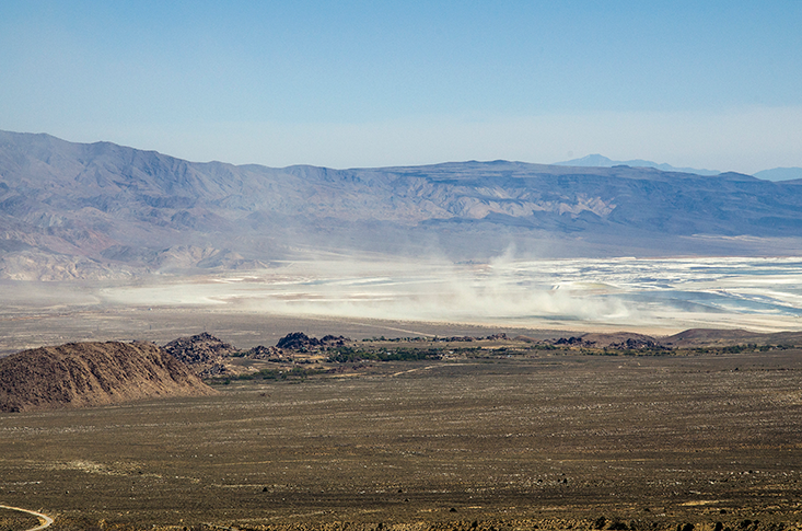
About 200 miles north of Los Angeles lie the remains of a dead body of water. The Owens Lake, on the eastern side of the Sierra Nevada mountain range, was never very large, even when the melting glaciers after an ice age flooded the lake via the Owens River. But at approximately 108 square miles in area in the 19th century, the lake, and the rivers feeding into it, were enough to sustain small communities that relied on it. Native Paiutes used some of the river water to nourish crops like wild hyacinth and yellow nutgrass. Other locals hunted the many animals that lived around the lake.
In the early 20th century, the lake’s water became a precious commodity to a growing, thirsty community 200 miles to the south. Los Angeles was a fast-growing city of about 100,000 people, and after having sucked the Los Angeles River dry in less than a century, the city was in need of a new source of water to continue its boom. The residents looked to the watery resource to the north, and President Theodore Roosevelt approved rerouting the freshwater to Los Angeles using the argument that it would mean “the greatest good for the greatest number.” Construction of an aqueduct to divert water from the Owens River down to Los Angeles began in 1908 and was completed by 1913. The lake had completely dried up by the mid-1920s.
Like the dry Aral Sea basin, the Owens Lake bed doesn’t just stay put. The fine grains of dust and crystallized salt from the dry bed are carried by the wind up and into the lungs of Owens Valley residents, causing health problems. In the 1980s, the EPA ordered Los Angeles to take care of the problem it had created within 10 years or begin paying daily fines. Numerous fixes were suggested, like using sewage or tires to cover the lakebed, to keep the dust packed down. Using water or gravel to keep the dust from rising up was deemed too expensive, although some half-hearted attempts were made. In November of 2014, after years of unsuccessful dust-containing experiments, a solution was finally offered and accepted. Tractors will dig up the still-damp soil under the lakebed and leave it in furrows and clumps, which is expected to contain the dust for years before the process is repeated again. Only time will tell if the latest solution holds.
Deep Problems
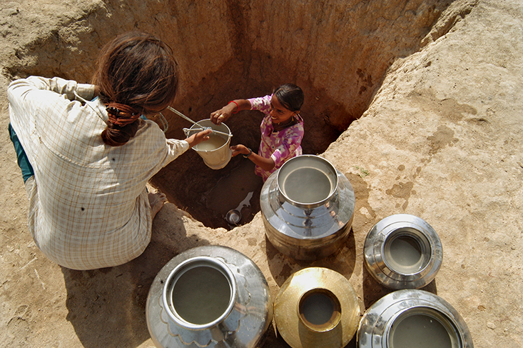
When water sources for thriving communities become polluted, the life-giving liquid has to be pulled from elsewhere. In India, many of the rivers crisscrossing the country are not viable resources for various reasons, like pollution from sewage or cremated bodies, and poor water-management policies. So to support its population of over 1 billion people, India pulls a lot of water from the ground, mainly via wells and boreholes that go down thousands of feet; consequently, the water from underground aquifers is becoming an endangered resource. The country uses a total of 230 cubic kilometers of groundwater each year, the most of any country in the world. Indian farmers tap into the groundwater across the nation not only to drink and to wash with, but also to feed thirsty fields of profitable grain crops. Eighty percent of the water used for irrigation in India comes from aquifers, and the supply is becoming very limited.
The problem with over-extracting groundwater is that the replenishment rate is slower than that of surface waters like lakes and rivers. In parts of northern India, where farming is heaviest, farmers drill and extract water three times as fast as it can replenish. And with a poor supply of water-sequestering infrastructure, like reservoirs and tanks, to refill when heavy rains come, these farmers have little hope of supplementing in a sustainable way the groundwater they borrow from below.
When the supply from underground runs dry, farmers simply move their wells, tapping into another fount of groundwater, or dig their holes even deeper. But the loss of groundwater resources has also forced many farmers to abandon their fields entirely. As the country overuses more of its aquifers, the remaining farmers can’t water their crops. And when crops die, people will find their food supply also becomes a limited resource.
Yvonne Bang is the assistant editor/video production manager at Nautilus.


