It’s a golden summer day, and I’m standing on a low coastal levee, overlooking a pond at Eden Landing Ecological Reserve that looks positively apocalyptic. Algae paint ruddy swirls in the brown water, its edge crusted hard with sparkling salt. As a breeze eases off the bay, a squadron of pelicans sails by, en route to more appetizing hunting grounds.
This pond is a legacy of a salt industry that has moved elsewhere. A few decades ago, when flying into San Francisco or San Jose, the ground beneath looked like a giant’s Easter egg dip. Ponds of blue, yellow, green, red, purple, orange, and pink ringed the South Bay. People had built low levees in semicircles from the shore, sectioning off portions of the bay to let the water evaporate, leaving behind the salt. The different colors were caused by varying levels of salinity and the types of organisms who could live in them—algae, bacteria, brine shrimp.
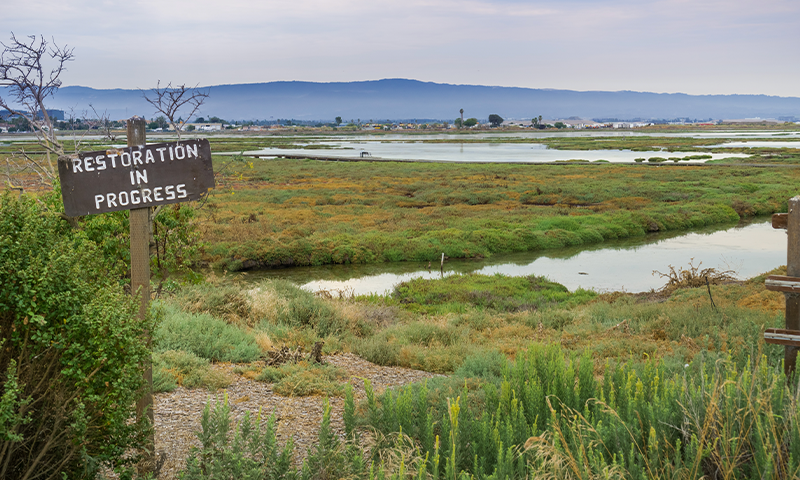
But today these former industrial sites present opportunity. Reverting more of this coastline from salt ponds and flood-control levees back to natural ecosystems could help protect the San Francisco Bay Area from sea-level rise. The pond I’m standing by is awaiting change. But as I turn my gaze west, toward the Golden Gate, I see something that looks much more natural: Whale Tail Marsh, a low-lying pastiche of variegated greens and tawny yellows whose restoration began 20 years ago. These two areas, side by side, are symbolic of nature’s resiliency, where we allow it, and how much work remains. Now, as climate change accelerates, coastal restorationists are running out of time.
Humans are often inclined to build seawalls to protect coastal communities from encroaching oceans, but those require constant, expensive maintenance. And in fact, the way we’re changing land, rivers, and climate—and even the seawalls themselves—are undermining natural protections, such as tidal marshes, barrier islands, coral reefs, seagrass beds, dunes, gravel beaches, and kelp and mangrove forests. If left intact, these natural communities can slow fresh and tidal water, acting as a buffer, providing flexible and resilient protection for human communities. They provide multiple co-benefits, and even have the ability to sustain themselves. With these abilities, they can reduce by half the number of lives and properties at risk from storm surges and sea-level rise, according to a study in Nature Climate Change.1
Unlike seawalls, tidal marshes have a superpower against sea-level rise. It’s not just that they are a buffer between the water and human infrastructure, sapping energy from storm surges and blocking the highest tides. Marshes can actually grow vertically, keeping pace with sea-level rise by trapping sediment in their vegetation, which decomposes and then regrows. To perform this trick, they need three ingredients: sediment, space, and time.
Marshes can actually grow vertically, keeping pace with sea-level rise.
“Marshes are in a dynamic equilibrium with the water level. It’s been clearly shown that, even at pretty high rates of sea-level rise, if there’s enough suspended sediment, they can keep pace,” John Bourgeois tells me that day at Eden Landing. A laid-back guy originally from Louisiana, Bourgeois has become a significant figure in San Francisco Bay’s marsh restoration. For nine years he was executive manager of the South Bay Salt Pond Restoration Project, a public-private partnership that manages wetlands restoration of former salt ponds in Eden Landing and other sites in the South Bay.
Restorers have documented the speed of marsh growth. In the town of Alviso, near San Jose on the edge of the South Bay, a protective marsh accreted more than 6 feet in 25 years. Another long-term restorationist, Letitia Grenier, interviewed local people about this feat. A bright, warm woman who’s been studying the ecology of the bay for two decades, she is now director of the Resilient Landscapes program at the San Francisco Estuary Institute, a scientific research organization that studies water, wetlands, wildlife, and landscapes. Alviso residents told Grenier that where they used to dock their boats along the slough with plenty of draft, there is now marsh. “When natural processes deliver the sediment, the plants grow up through it, and the living marsh stays on top and the sediment keeps accreting,” she tells me when I visit her office in Richmond, California.
Can San Francisco Bay’s marshes even keep up with fast sea-level rise? I ask.
“The answer is yes, if they have enough sediment. Although,” she amends, “when sea-level rise accelerates very rapidly, it’s anybody’s guess, because we’ve never seen that before.”
Restorationists in San Francisco Bay may have the time they need to restore all available coastal land because sea-level rise is happening a bit more slowly on the United States West Coast than on the East and Gulf Coasts for complex reasons. California has seen about 6 inches of sea-level rise over the last century, although that’s still enough for some low spots to start flooding during king tides, such as San Francisco’s famous Embarcadero at the foot of Market Street and parts of San Mateo and Marin Counties.
But there’s not a lot of time. The rate of sea-level rise is expected to accelerate as the century goes on. Levels could rise by as much as 7 feet by 2100, the California Ocean Protection Council estimates, and that would threaten infrastructure, including airports, electricity plants, transportation, and drinking-water facilities—many of which lie low and close to the bay.
Bourgeois and Grenier are part of a vast, loose group of scientists and local government officials who have been working to fulfill a goal set in 1999 to restore more than half the 190,000 acres of marshes the bay had historically. Although precise documentation is lacking, experts estimate that, at the low point in the mid-20th century, just 10 percent of the historic marshes remained.
Today, about 28 percent of the historic marsh area, or approximately 53,000 acres, is marsh or being restored to marsh. In 2016, marsh allies refined their goal, making it an explicit objective to restore as much acreage as possible by 2030 for maximum resilience to sea-level rise. Currently planned restoration projects would add at least another 22,000 acres of marsh for a total of almost 40 percent of the original marsh area. The easiest large tracts of land to acquire and restore have already been slated for repair. Remaining open space around the bay is plentiful in certain areas but is privately owned, and some has subsided below sea level, which makes it expensive and difficult to restore to tidal elevations. Still, the goal is 100,000 acres total, if the group can leverage other opportunities for restoration.
Getting that space, someway, somehow, is one of the critical three ingredients marshes need to work their wonders. But in the heavily populated Bay Area, like in many other water-fronting places around the world, space is at a premium. Just behind the marshes lie freeways, sewage treatment plants, technology campuses such as Facebook and Google, and local neighborhoods. That human infrastructure is problematic because marshes need room to migrate inland and because they are part of larger systems.
“You can’t just think of the marsh,” Grenier tells me—a systems theory lesson the scientists have learned by doing. When they started restoring Bay Area tidal marshes, they thought, “We’ll just breach [the levee creating] this salt pond that used to be a marsh,” she tells me. “We’ll let the sediment come in, it’ll be a marsh again. Boom. We’re done.” As they studied how marshes work, they realized the truth: “These are much bigger systems.”
Thanks to fresh and salt water moving through them, marshes interact with several other neighboring, intertwined ecosystems, both upstream and out into the deeper water of the bay. It’s a mobile spectrum: the subtidal ecosystem, populated by eelgrass and oysters; mudflats where egrets and endangered California least terns hunt; the low marsh with its Pacific cordgrass; the marsh plain featuring pickleweed, a tiny segmented succulent that—surprise—tastes salty; the high marsh with its gum plant; and finally, the transition zone reaching into the uplands, home to shrubs and multiple species of oaks. When free from human-made barriers, the zones exchange critical sediment and nutrients with the help of streams flowing down from the uplands and tides pushing inland.
“If you just have the marsh, it’s not as resilient as if you have the full system because each element protects what’s behind it,” Grenier explains. In their natural state, these ecosystems achieve “dynamic stability”—not an oxymoron, but a resilient state of flux in which they maintain themselves. That’s why marshes need space: They grow upward in part by slowly marching inland. Where they have room to move, they can creep over sediment in the uplands, feeding themselves as they go.
Marshes need space: They grow upward in part by slowly marching inland.
Marshes aren’t the only borderline between land and water along San Francisco Bay. Historically there were about 27 miles of sand, shell hash, gravel, and cobble beaches along the bay. Now there are hardly any; they’ve been replaced by artificial fill, riprap, or walls of large stones or concrete. But like the tidal marshes, the gravel of days gone by also absorbed wave power, like a football player who rolls when tackled to diffuse force on the body. Because riprap and seawalls are hard barriers, they don’t absorb wave energy but instead push back against it, banking it onto neighboring marshes, eroding them. Other restoration projects around the bay are now seeking to replace them with gravel, sand, or shell beaches in some places.
To find space for these natural cushions, restorationists look for opportunity from the human side, restoring places that have become available because they are now less attractive to people, such as the salt ponds.
But they are also looking to water to guide them. I came to think of the tidal marsh restorationists and other experts as water detectives, because they are all trying to understand water’s agency and processes by asking a rather radical question: What does water want? To answer that question, people restoring tidal marshes rely on the work of historical ecologists at the San Francisco Estuary Institute, who seek to discover what water once did in this landscape before development obscured its patterns. They then create maps showing where water wants to go, overlaid on modern development, that can help people understand where keeping water out may be a losing battle, and where relinquishing acres to nature can have a big impact on protecting adjacent human habitat.
Broadly speaking, human development has erased many of water’s slow phases—floodplains, meadows, forests, and wetlands, such as tidal marshes. For example, humans have eradicated 87 percent of the world’s wetlands. What water wants, say the detectives, is a return of these slow phases, an approach I think of as the “Slow Water Movement.” Slow water approaches are unique to each place, work with local systems, are distributed rather than centralized, are socially just, and empower and engage the local community. They also provide multiple benefits beyond buffering us from flood and drought, including carbon storage and homes for threatened plants and animals.
In San Francisco Bay, the effort by scientists and local governments to restore as much tidal marsh as possible is well underway. But in their ambition, they are coming up against a challenge. They need more of the third and final ingredient that marshes require to heal and grow: sediment. Existing tidal marshes and mudflats are unlikely to receive enough sediment naturally in order to survive sea-level rise this century, according to a 2021 report from the San Francisco Estuary Institute.2 Without supplemental sediment, many will drown by 2100.
In a natural system, fresh water from upstream rivers and brackish and salt water moved by the tides play critical roles in delivering sediment to marshes. But humans are blocking sediment delivery. This phenomenon affects San Francisco Bay, as well as many other river deltas around the world: the Mississippi, the Niger in Nigeria, the Indus in Pakistan, the Ganges–Meghna–Brahmaputra in India and Bangladesh, the Irrawaddy in Myanmar, the Mekong in Vietnam. Upstream dams trap sediment behind them. And leveed, channelized rivers shoot water and the reduced sediment it carries off the land and out beyond tidal mudflats. Depriving the near shore of sediment leaves a delta without enough raw material to keep up with normal coastal erosion, let alone rising seas. That’s one reason Louisiana has been losing land. And hardening the shoreline blocks tide-carried sediment from building land seaside.
If the San Francisco Bay restorationists are to be able to fulfill their plans to revive more of the marshes, they will need extra sediment. The old salt ponds are 1 to 2 feet below sea level for a few reasons. The biggest: Diking them off from the bay blocked tides bearing land-building sediment. Groundwater pumping also caused the land to sink. Dave Halsing, current manager of the South Bay Salt Pond Restoration Project, tells me on the phone that just opening a pond to the tides and allowing it to accrete naturally might take five to 20 years depending on the depth of the pond. That could be too slow to beat sea-level rise. The need for sediment has restorationists searching high and low for more so they can fill the subsided holes to jumpstart the natural restoration process. But they require a lot.
The lead author of the San Francisco Estuary Institute’s sediment report, geomorphologist Scott Dusterhoff, quantified the sediment required both to maintain existing marshes and mudflats and for additional planned marsh restoration. If sea levels rise by 6.9 feet by 2100—a moderate-to-high-risk scenario in which humanity doesn’t find the will to reduce emissions—they’ll need more than 600 million tons of sediment.
Some could come from upstream. Dusterhoff calculated that by 2100, without intervention, creeks could deliver 176 million to about 309 million tons of sediment to the bay. The variation is due to drier or wetter future scenarios. With less rain, there will be less water flowing down creeks to the bay carrying less sediment. With some intervention, such as removing derelict dams or building new dams that allow sediment to pass, creeks could deliver more. According to Dusterhoff, an additional 353 million tons of sediment could be harvested by 2100 from bay dredging for ship traffic. And another 165 million tons excavated during local construction could be put to use.
Added up, there’s likely enough sediment in the region to make up the deficit. It’s a matter of getting the dirt to where it’s needed. Brenda Goeden, sediment program manager for the San Francisco Bay Conservation and Development Commission, understands the value of muck. Her email footer reads, in elegant script: “No mud, no lotus—Thích Nhất Hạnh.” She said, “Given what we understand about climate change and what our regional scientists tell us, we have 10 to 15 years to get our act together in the Bay Area with marshes before we see an uptick in sea-level rise.” 
Adapted from Water Always Wins: Thriving in an Age of Drought and Deluge by Erica Gies, published by University of Chicago Press. Copyright © 2022 by Erica Gies.
Lead image: Sundry Photography / Shutterstock
References
1. Arkema, K.K., et al. Coastal habitats shield people and property from sea-level rise and storms. Nature Climate Change 3, 913-918 (2013).
2. Dusterhoff, S., McKnight, K., & Grenier, L. Sediment for survival: A strategy for the resilience of bay wetlands in the lower San Francisco Estuary. sfei.org (2021).