I am paddling through the silt of the Green River, the largest, most remote, and least developed tributary of the Colorado River, which brings water to nearly 40 million people across the western United States. It’s crucial, it’s overused, and it’s at risk.
The Green starts in the glaciated high alpine of Wyoming’s Wind River Range, then winds through hundreds of miles of sagebrush flats, scrubby plains, tight gorges, and empty gas lands to the red rock desert of Utah’s Canyonlands National Park, where it meets up with the main stem of the Colorado. All signs of western development—from coal to cattle to cities—surround the river. As population swells in cities like Denver and Salt Lake, and as climate change shrinks stream flow, the question of how the water in this river is used and how far it can be stretched is becoming more urgent.
Like nearly all water sources in the western U.S., it’s been dammed up, spread thin, and abused. Drought has wracked most of the western half of the U.S. since the beginning of the 21st century, draining reservoirs and depleting aquifers. Water is mired in the future of the climate, it’s tied to the physical, political, and economic divide between urban areas and rural ones, and it’s crucial to the debate about future energy sources. And more than anything, it’s indispensable. More than oil. More than food.
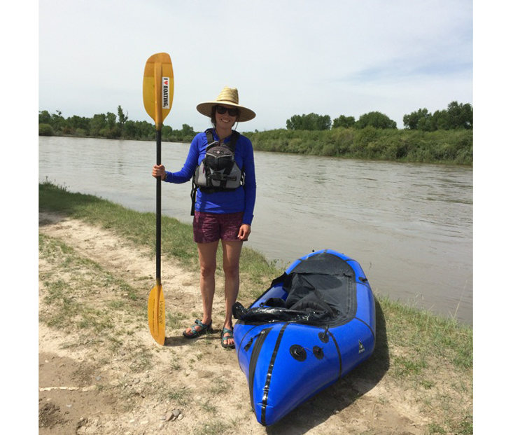
I’m paddling downstream into the pooled up water of Fontenelle Reservoir, formed by the first dam on the river, one of two major storage sites on the Green. My pack raft is about as long as I am tall. I paddle it with an old, chipped kayak paddle, bought in the days before I realized I was too nervous to be any good at whitewater kayaking. The little raft feels slightly more stable than a kayak and is easier to wrangle than a canoe or a full-sized raft, but it’s easily deflected by wind, and it feels flimsy sometimes when I’m alone.
I’m particularly curious about Fontenelle because I want to know more about how dams changed the dynamic of the river. Coming into the trip, I knew enough about reservoirs, dams, and storage to think about them as a necessary evil: manmade breaks in the ecosystem to be worked around and reckoned with. I had the view that dams were, for the most part, bad, environmentally destructive, and stupid, and that they should be removed wherever possible. But I’ve been on the river for two weeks now, and the more I talk to people who touch the water every day, the more I realize how naïve and unsubtle my thinking has been.
How the West Was Won
In the morning, I cold-call Kirk Jensen, who runs the Fontenelle Dam and Power Plant, to ask if I can see the inside of the dam. “Is now good?” he says. “We’ll open the gates for you.”
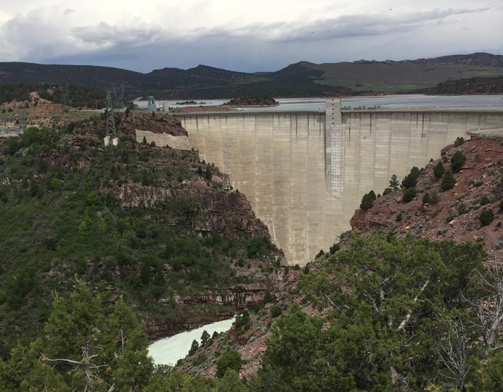
Fontenelle is a utilitarian dam. It has square corners and lacks any kind of architectural grace. When Jensen walks me inside, I get the feeling that a random visitor is a rare occurrence. He leads me into the narrow, humming control room, which is lined on both sides with analog dials and switches. It feels like we’re inside a submarine, monitoring water pressure below the surface.
I follow him down a set of skinny stairs to look at the guts of the power plant. Fontenelle has a single Francis-style turbine, a kind he says is often used on rivers with large flows and dams with steep drops. The turbine creates a small amount of power—10,000 kilowatts—but Fontenelle mainly operates to store and supply water and to keep its reservoir, and Flaming Gorge Reservoir downstream, at certain levels. The amount of water pushed through the dam is based on river flow and demand downstream.
The general public doesn’t know what the dams do. They’d be at the mercy of the rivers without them.
The Seedskadee Project, the official name of the Fontenelle Dam construction project, was authorized under the Bureau of Reclamation’s Colorado River Storage Project Act of 1956. The bureau, an agency in the U.S. Department of Interior, provided jobs in the wake of the Great Depression, and it did what it set out to do: It provided a large-scale plumbing system for expanding agriculture and growing cities. The bureau has long defended its dams and reservoirs because they provide agricultural, household, and industrial water to about one-third of the population of the American West, and that’s true. We’ve staked life in desert cities on their ability to deliver water steadily. Water storage is a big part of the reason people can live in areas where it doesn’t rain.
The Colorado River Storage Project Act initiated construction of a number of large dams, including Glen Canyon and Flaming Gorge as well as Fontenelle, with the intent to manage and mitigate risk in the upper Colorado River and to control flows between the Upper and Lower Basins. By the time Fontenelle was built in 1963, it had already become clear that there was less water in the river than was allocated in the Colorado River Compact.
There’s a constant thrumming fear around the lack of storage in the Upper Basin, and because of that anxiety, Fontenelle is at an interesting crossroads. It was initially built to supply water for irrigation, but that never happened. The area around it is too dry, gravelly, and cold to grow crops. A test farm run by the bureau after dam construction started quickly proved that, so these days, Fontenelle is a storage reservoir, which helps guarantee that Wyoming can get its designated 14 percent of the Upper Basin’s water.
When Jensen and I walk out onto the deck above the turbine, a tempest of whitewater flows into the river below us. With the laconic practicality of a government engineer, he explains what the course of his year looks like. Spring, which comes with a rush of snowmelt that needs regulating, is when things are busiest, because he’s trying to balance runoff with downstream water needs and with filling the reservoir for the upcoming summer and fall. He says the reservoir is usually at its highest around July 4, and he thinks they’ll fill it up this year. After an unusually dry winter, the spring has been wet and cold, and it’s been raining more than normal. He says they’re pushing 1,550 cubic feet per second out of the turbine right now. If the reservoir gets too high and they need to dump water, they can let out as much as 6,500 cubic feet per second through bypasses that flow around the turbine. If they release more than that, they start to flood out the fields around Green River. “We have to control it slowly,” he says.
The city of Green River, with a population near 13,000, is highly dependent on Fontenelle, both to prevent it from flooding with spring snowmelt and to keep its supply of water steady though the year. Because the water treatment plant currently can’t store much more than a few days’ supply, it relies on the dam to release the water it processes so residents have something to drink. The river makes the city livable, but the dam makes it possible to live there year-round. “The general public doesn’t know what the dams do. They’d be at the mercy of the rivers without them.” We watch water pound out into the eddy below the dam. “People don’t realize how much we need this,” Jensen says.
No Turning Back
There are an estimated 90,000 dams in the U.S., ranging in size from inches high to the Hoover Dam’s 726 feet. Dams of any size irrevocably change complex river ecosystems. As soon as water backs up behind a dam or diversion, it moves through its former channel differently. Stagnation alters both physical and chemical characteristics. When dams artificially slacken water that used to move, they alter its temperature, its dissolved oxygen content, and the ability of native plants and animals to live in it. Reservoirs, which emit methane, contribute to greenhouse gas emissions. The sweeping canyons of Flaming Gorge are beautiful, but the reservoir is a constructed, changed ecosystem, and, as I’m learning every day, beauty and nature aren’t necessarily the same thing.
The 2000s brought a wave of backlash against existing dams and an effort by environmental groups to remove structures deemed unnecessary, environmentally destructive, or dangerous. That dam removal movement has worked really well in some places. After the Elwha and Glines Canyon Dams, on Washington’s Olympic Peninsula, were removed, in 2012 and 2014 respectively, native salmon populations rebounded almost immediately, and the river’s delta stabilized, thanks to increased sediment loads, creating habitat for elk and other animals. In Maine, when the Veazie Dam came down on the Penobscot River in 2013, fisheries came back, boosting the economy in the area. But a lot of the successful dam removals have been on rivers where water storage isn’t important, or where power-generating infrastructure is no longer relevant. The cause and effect isn’t always as straightforward as those projects have been.
I had the view that dams were destructive and stupid, and should be removed wherever possible.
The reservoirs of the Colorado River system, from Fontenelle down to the Morelos Dam on the U.S. border with Mexico, are the largest in relation to the river’s stream flow in any watershed in North America. The river is stopped up, slaked off, and used up to the point that it dries up a hundred miles inland from its delta. But if Fontenelle Dam were to disappear tomorrow, Rock Springs, just off the main stem of the river, would be dry by midsummer. In a human-constructed and constrained system, the positives and negatives aren’t in balance. You can’t look backward and think about ripping out dams without taking the present into account. People are important. An idealized version of what the river looked like before the dam isn’t an accurate or useful goal.
A lot of the anti-dam arguments put forth by environmental groups and scientists are based in hydrology and biology. Dams will stress a watershed almost beyond repair, and they fundamentally change the river’s function. Jack Schmidt, a fluvial geomorphologist and professor of watershed sciences at Utah State University, who has spent much of the past four decades working on the Colorado River system, says he thinks it’s impossible to fully restore pre-dam conditions. Despite that, he’s constantly trying to recreate the past, and to help manage rivers in as natural a state as possible, to maintain ecosystem integrity. The hard part is figuring out what counts as natural and how to preserve multiple aspects of the river at once: to manage for native fish and the fly-fishing economy that’s sprung up below the dam at the same time, or for both power generation and stable base flows.
Schmidt, who is a paddler and a river junkie in addition to being a sediment nerd, has been looking at the Green since 1992, when the superintendent of Dinosaur National Monument asked him to evaluate the impact of the Flaming Gorge Dam on the rest of the river. That’s his specialty. Fluvial geomorphology is the study of how a river changes itself physically: how the channels narrow and vary, and how flood patterns—man-made or otherwise—affect the landforms and sandbars along its course.
Those changes are both consistent and mysterious. Allegedly, when Albert Einstein’s son Hans declared that he wanted to study fluid dynamics, Einstein asked him why he’d ever want to look at something so hard. Geology adjusts on a granular scale. As rivers flow downstream, they’re constantly moving sediment loads downstream, too, in the slow rolling force of geologic history. Like race cars, rivers move faster around the outsides of corners, building up sediment on the insides as they lose centripetal force. Migrating sandbars switch side to side as they move downstream, and they vary over time, alternating cut banks and point bars, eroding from one side of the river and loading the other bank.
Spring floods set the sediment in motion as they flush more powerfully erosive flows downstream. On the Green River, below Fontenelle and Flaming Gorge, those floods don’t happen like they used to because of the dams—if you have smaller floods, you have less pushing. Even with the dam-created spring peak flows for the fish, the river can never run higher than the 8,600 cubic feet per second that Flaming Gorge will release with all the floodgates open. Sediment accumulates in reservoirs, and dams change the way alluvial fans build up: They can stagnate and grow over, or they can wash downstream. That’s what Schmidt is trying to understand.
In Browns Park, downstream from here, the river is between 10 and 25 percent narrower than it was at the beginning of the 20th century. Schmidt thinks that’s because of the lack of early-season floods and the resulting ecological changes. Non-native vegetation, like tamarisk, which thrives in the alkaline soil here and has long, many-tentacled root balls that hold riverbanks together, has changed the channel size. Those physical forces then trigger biological outcomes—they break down habitats and change what kinds of species can live where. “Scientifically, we have to worry about the flow regime, how the timing and the magnitude of the flow regime triggers natural ecosystem processes,” Schmidt says.
Those impacts carry far downstream, and they’re exacerbated by drought, climate change—which comes with variable runoff and increasing temperatures—and those non-native fish and plants that have spread across the river’s system. Schmidt says that, all things considered, the Green has the healthiest river ecosystem of any part of the Colorado River Basin, in part because the untouched Yampa River, which flows in just south of here, adds so much to its flow, but it’s still highly changed. Nothing is untouched anymore. When a river’s flow is reduced or altered, which is happening across the West, it’s less dynamic, degraded, simplified. And that means it’s less naturally resilient.
What the Bugs Say
Out here alone, where I have space to focus on the river, the interconnectedness feels vivid and impossible not to think about—the way the water slowly changes from clear to murky below the dam, or the intakes pump water up to wells in surprising places. It changes the way I think about the river as a whole, because I’m realizing how much I was wrong, or narrow-minded, about.
Sometimes, to show the big picture, it’s helpful to focus on something small. To gauge how dam operations impact everything below the power plants, scientists have been looking at one of the bases of the food chain, the insects. Because the bugs are close to the bottom of the riparian food web, they’re bioindicators for the whole system, indicative of the health of the river.
An idealized version of what the river looked like before the dam isn’t an accurate or useful goal.
On the Green River, USGS research scientist Anya Metcalfe has been looking at insect diversity in the river, and she’s started a citizen science campaign to collect data. She sends boaters like me out with a bug-trapping kit. I carry a rectangular metal ammo can painted sky blue and filled with bottles of ethanol, a light, and a paperback book–sized tray. At night, after I make dinner, I set the tray on the riverbank, pour one of the ethanol bottles out into it, and leave the light shining on it for an hour. When I come back, it’s often filled with the carapaces of dinosaur-like bugs, a sample of what’s living in the section of river I’m on. “It’s a proxy to look at the river,” Metcalfe says. “It’s a really powerful tool to understand the availability, what bugs are there, and how many are there.”
Metcalfe is trying to get a sense, over time and space, of how many bugs are in the river because that can show how many fish can survive there. The goal of the project is twofold. She’s gathering a vast map of data, but she’s also hoping that the boaters who capture the bugs start thinking about what it means, and why they might not find any insects in one place, but a lot somewhere else. She thinks it’s a line in to caring about the river, and a way to give people a stake.
Metcalfe is spearheading bug tracking on the Green, but she and other researchers in her lab at the Grand Canyon Monitoring and Research Center have been tracking insects in the Grand Canyon, below Glen Canyon Dam, since 2012, and they’ve found that the impacts of the dam are significant. “Something that became immediately obvious is that there’s not a lot of diversity. Midges, blackflies, micro caddis flies—that’s all we’ve been finding,” she says. “With classical ecology in the river continuum you’re supposed to get more diversity as you go downstream, but the recovery rate is really slow. One-hundred-fifty miles from Glen Canyon we still have low diversity.”
They’re not seeing many types of bugs even though algae, the insects’ main food source, is healthy. They’re trying to figure out why, because without bugs, the fish are hungry and struggling. They think that peaking the dam’s releases based on hydropower-needs might be washing bug larvae downstream, and that temperature might play a role, too, so they’re trying to figure out what dam operators can do to create better conditions for bugs and fish, how they can use man-made tools to mimic natural cycles, or mess up the river less. The water coming out of Glen Canyon Dam, which comes from the bottom of the reservoir, is incredibly cold, and the researchers think that’s rough on the native flora, which was historically used to warm river temperatures. At Flaming Gorge Dam they’ve installed what’s called a selective withdrawal system, which lets them pull water from whichever layer of the reservoir they want, adjusting the temperature of what’s released downstream. They think that helps bug viability downriver. “Immediately below Flaming Gorge looks a lot like the Grand Canyon, but 15 to 20 miles downstream you start to get the foodstuff bugs, like stone flies and caddis flies,” Metcalfe says. “They’re classic indicators of healthy, happy ecosystems.”
Metcalfe says she’s excited by the idea that dam managers are thinking about bugs and are working within the framework of the system to try to manage for them. “We can’t restore the river because it would require taking out the dam, but we can understand how the dam impacts ecosystems, then try to understand how to best manage it,” she says. “You can’t always manage for restoration, but you can try to manage for a healthy ecosystem.”
Healthy is a tricky, subjective word, couched in expectation and endgame. It means something different to people who live in Rock Springs than it does to the fish biologists, and none of them are wrong. And the longer I spend on the river, balancing those expectations, and giving them all weight, feels like the hardest, most important part.
Heather Hansman is the author of Downriver: Into the Future of Water in the West. She is a former raft guide and a current environmental journalist.
Adapted with permission from Downriver: Into the Future of Water in the West, by Heather Hansman, published by the University of Chicago Press. © 2019 by The University of Chicago. All rights reserved.
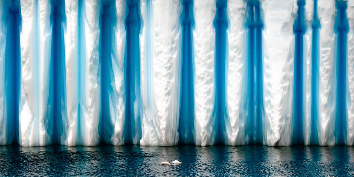
Lead Image Credit: PriceM / Shutterstock