

In the first half of the sixth century B.C., a Greek man named Anaximander, born in Turkey, sketched the world in a way no one had previously thought to do. It featured a circle, divided into three equal parts. He labeled those parts Europe, Asia, and Libya, and separated them by the great waterways of the Nile, the Phasis river, and the Mediterranean. To call it a map would perhaps be a bit overgenerous. It was really more of a schematic. But it nonetheless represented a crucial innovation. Anaximander had rendered the world in a way that no person had ever seen it before: from above.
Anaximander’s sketch wasn’t especially useful as a cartographic instrument, and it also came with some peculiar conceptual baggage. He believed the earth sat atop a column, following the architectural sensibilities of the day. It was Plato, several hundred years later, who proposed the idea of a spherical earth. He had no strong, principled reason to do this; the guy just liked spheres. But though they were fascinated by the shape of the earth, neither Plato nor Anaximander, nor even Aristotle, can count among their accolades credit for creating the first scientific map of the world. That distinction falls to a North African man by the name of Eratosthenes.
Eratosthenes is best known today as the founder of the field of geography. He coined the term in his magnum opus, Geographika, published during his tenure as the head librarian at Alexandria, sometime between 240 and 220 B.C. It was three books in length and covered topics ranging from climate zones to the geological history of the planet to the customs of different populations. What Eratosthenes offered in this book was a perspective informed by data. Any prior works that touched on these topics had been conceived in much the same way as Anaximander’s schematic: a vague suspicion about what was out there, unconstrained by any commitment to describing its actuality.
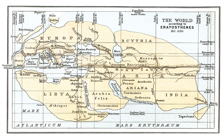
We don’t actually have a copy of Eratosthenes’ original map (it probably burned down with the Library of Alexandria). But the Roman geographer Strabo, in the first century B.C., constructed his own map, which we do have, based off of Eratosthenes’ original—a sort of tidying-up, rather than a total rewrite. He quoted at length from Eratosthenes’ text, including detailed descriptions of the original rendering, so historians today have a pretty good idea of what Eratosthenes’ map probably contained.
In Eratosthenes’ map, the world’s landmass looks like a parallelogram. It is divided into four quadrants. They are, roughly, Africa, Europe, Russia, and India—or at least that’s what we’d call them today. As far as maps of the world go, it features—to make the point gently—some peculiar omissions. The Americas, Australia, and East Asia come to mind. Even in what Eratosthenes does try to depict, he fails to grasp how expansive the earth’s landmasses really are.
Our conception of the world is based on what we think is out there. In fact, that’s all we think the world is.
From our perspective, it’s clear that Eratosthenes didn’t know what the world looked like. What’s a little trickier to explain is it didn’t really occur to Eratosthenes that his map might be off. He was confident he had pretty much nailed it. He claimed, for instance, that the only reason no one had yet sailed around the world was because of unfavorable tides, and not for more consequential reasons—like the existence of the rest of Africa, China, and Russia.
In the famous first line of his Tractatus Logico-Philosophicus, the philosopher Ludwig Wittgenstein presented his readers with a proposition: “The world is all that is the case.” Though Wittgenstein meant this as a claim about the bounds of logic, it can also be interpreted psychologically. Our conception of the world is based on what we think is out there. In fact, that’s all we think the world is—whatever’s out there.
What’s changed since Eratosthenes’ days is technology. We now have detailed images of what the world actually looks like. What hasn’t changed are the ways our minds make sense of our surroundings. The map of Eratosthenes resembles something we all do—reconcile the terrain around us with what means the most to us. The ancient geographer didn’t just produce the first map of the world. He gave us an insight into the kind of map we carry in our own heads to this day.
The idea that an animal’s brain creates a map of its environment as it runs around in it was first proposed by Edward Tolman, in his influential 1948 paper, “Cognitive maps in rats and men.” Tolman’s initial proposal was simply that the brain uses some sort of spatial representation to organize knowledge about the layout of the world. In his experiments, Tolman would set a rat at a random point in the maze, then measure how long it took the rat to find her way to the cheese. As expected, the rats got quicker each time Tolman put them in the maze. Tolman then compared this with a second condition. He would put a rat in the maze, but without any cheese. The rat would wander aimlessly, and whenever she got to the place where the cheese would have been, Tolman would take her out and set her back in the cage. The rats in this condition each did five of these non-cheese trials before moving on to the normal cheese-motivated trials.
What Tolman’s contemporaries would have expected to see was that the non-cheese trials didn’t matter. The accepted theory of the day was that learning was motivated by reward. And without the cheese there was no reward, and therefore no learning. But that’s not what Tolman found. What he discovered was that as soon as he began putting the cheese in the maze, the rats who had merely been wandering were able to solve the maze just as quickly as those who had been going after the cheese the entire time. The reason for this, Tolman explained, was that the rats were creating a cognitive map of their environment the whole time. Once they knew where in that map the cheese was, they could go straight there.
The Parisians should have known how far they were off. But they confidently asserted they were right.
In this sense, Eratosthenes’ map of the world can be thought of as a sort of cognitive map, worked out in pen and paper. Like Tolman’s rats, he developed a picture of what he thought was out there. Except, unlike the rats, Eratosthenes couldn’t just traipse around the world to get a feel for it. He made up for this with a particular strength of his: working out new conclusions from existing data.
Eratosthenes had little respect for disciplinary silos. He wrote quite a bit of philosophy, and his contemporaries considered his work adequate but derivative. He was a decent poet, but by no means the most renowned of his generation. The same could be said of his status as a mathematician. His friends, picking up on this pattern, took to calling him “Beta” because he was, according to them, second best in everything.
During his younger years Eratosthenes had a particular interest in prime numbers. His most celebrated mathematical invention is known today as the Sieve of Eratosthenes. The Sieve—which rhymes with “give”—is an algorithm for generating a list of all the primes up to a chosen number. To this day, it’s still the most efficient way for a computer to generate all the primes up through about 100,000. The payoff for this idea would come far after Eratosthenes’ own lifetime, as it is relevant in contemporary fields like number theory and cryptography.
The intellectual feat that garnered Eratosthenes the most fame in his own lifetime was his estimate of the earth’s circumference. He managed to get within about a tenth of a percent of the modern calculation using only Euclidean geometry and a few simple measurements. It was well known in the ancient world that the sun was directly over the city of Syene during the summer solstice, because of a deep well that cast no shadow. And the length of the Nile from Syene to Alexandria was also known, because it had recently been surveyed by Ptolemy II. So one day on the summer solstice, Eratosthenes measured the angle of a tall building in Alexandria. He got a reading of 7.2 degrees. Doing the math, this meant that this section of the Nile was exactly one-fiftieth of earth’s circumference (if you cut a pie into 50 equal pieces, the interior angle at the point of each slice would be 7.2 degrees). His calculation was off by about the distance between JFK airport in New York and Newark airport in New Jersey along I-95; in other words, you could walk Eratosthenes’ margin of error in about nine hours. One historian calls Eratosthenes’ estimate “a feat so profound yet so simple that it remains today one of the most amazing pieces of ancient scholarship, treated as such since antiquity.”
There’s a Greek word, philologos. Literally it means “lover of reason,” but at its heart it meant a learned person, an academic. It was a somewhat pejorative term. An ancient Greek might use it in the same way we might say today that someone is a thinker, as opposed to a doer. Eratosthenes, allegedly, was the first to use the word to describe himself. That’s sort of like someone today being declared the first “thought leader.” Not necessarily by anyone else, but according to their own estimation.
Of course, he was probably correct.
In 1976, the psychologist Stanley Milgram had just come off a decade-long research program on obedience to authority, in which he induced participants to shock one another in a dingy basement on the campus of Yale University. Milgram had recently moved to Paris, where he was keen to employ an experimental paradigm that was decidedly more benign. In particular, he was interested in what he called people’s “psychological maps” of the city. “It is not,” he wrote, “an examination of Paris as a geographic reality, but rather of the way that reality is mirrored in the minds of its inhabitants.” How, in other words, do people’s psychological maps differ from the way Paris actually looks? “The first principle,” as Milgram put it, “is that reality and image are imperfectly linked.”
What you might have expected Milgram to find is that his participants’ maps looked like impoverished versions of a tourist map. After all, each of Milgram’s participants would have seen the canonical map of Paris—featuring the Eiffel Tower, Notre Dame, the Arc de Triomphe—hundreds of times. To be sure, their hand-drawn maps wouldn’t look exactly like the actual map; these people are not professional cartographers. But there is no doubt that they would have been familiar with the real thing represented as it actually is. They could also rely on their quotidian interactions with Paris, wandering its streets and traversing the cityscape as they go about their business. But that was exactly the problem.
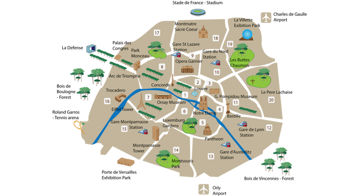
What Milgram found is that people’s maps were more strongly influenced by their own idiosyncratic experiences than a general knowledge of the city’s layout. One map was drawn by a 50-year-old woman who had lived for 15 years in the city’s Fourth Arrondissement. She mapped that area, just north of the Seine, in scrupulous detail, down to the direction of the one way streets. But she included almost no landmarks south of the Seine, except for Montparnasse—no Eiffel Tower, no Musée d’Orsay, no Jardin du Luxembourg.
In this respect, her map is representative of what Milgram found overall. Almost half of Milgram’s participants failed to include the Eiffel Tower and other major landmarks. “She centers her map not on Paris as a whole,” wrote Milgram, “but on a segment of it that has special meaning to her.”
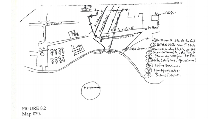
When you look a little closer, the maps of Milgram’s Parisians were off in much the same way as Eratosthenes. Eratosthenes, so to speak, mapped the one way streets around Alexandria, Athens, and the Mediterranean, where he lived most of his life. But he failed to get any details right once he set his sights on more distal terrain, like India or southern Africa. And just as with Eratosthenes, the Parisians didn’t think their map was perfect, but they thought it was pretty much correct. The difference here is that, unlike Eratosthenes, they had seen the real thing. They should have known how far they were off. But they still confidently asserted that the reality in their head corresponded with what was out there. It didn’t.
So what exactly had Eratosthenes seen that informed his map? That answer begins, as it so often does for these sort of things, with Aristotle. In his Meteorologika, Aristotle documented an interest in the earth’s surface. He was the first one to provide an estimate of the circumference of the earth (it was way off). But most of his work ultimately didn’t go much further than speculation. After all, how could he possibly know what the rest of the world was like when he’d never seen it?
So when Aristotle began tutoring a young pupil named Alexander around 340 B.C., there were many questions about what the earth looked like but not many answers. Alexander, for his part, took a certain pragmatically-inclined interest in questions about the surface of the earth. This was probably connected to the fact that he would, over the next couple decades, go on to conquer most of it.
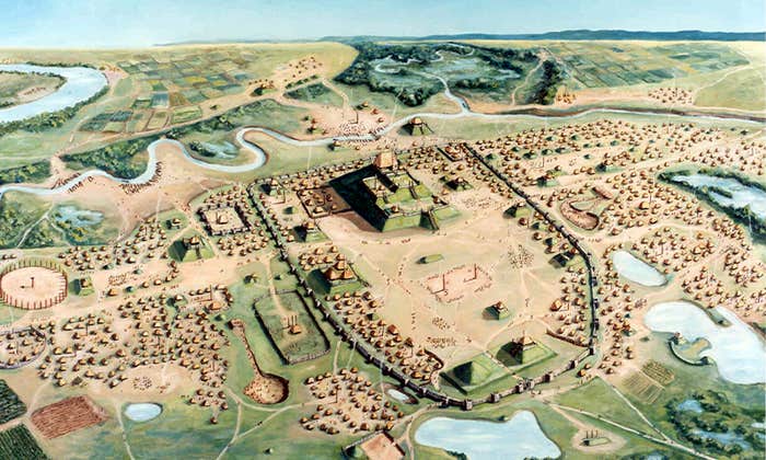
Alexander’s campaigns went throughout most of Asia minor—northeastern Africa, Macedonia and the Hellenic peninsula, the eastern Mediterranean, Arabia, and into India, just north of Bombay. These campaigns started in 336 B.C. and continued until 323 B.C., the year of Alexander’s death.
By the time Eratosthenes took his station at Alexandria, all of Alexander’s military personnel had returned from their travels, compared notes with one another, and had written up reports about what they had seen. And where do you think they kept those reports once they’d been filed away? The Library of Alexandria, naturally.
Eratosthenes had what Aristotle did not. He had data.
Which is what puts Eratosthenes on the same playing field as the rest of us. We can only use the data available to us to paint a picture of what’s out there. Like Milgram’s Parisians, and Tolman’s rats, we each construct a map of reality as we go about our business in the world. And like them, we assume that what our version looks like is the real thing. The risk we run is to mistake the representation for the reality. We might think that we are exempt us from the kind of mistakes Eratosthenes made, because we simply have access to so much more reliable information. But that isn’t a guarantee. In the Geographika, Eratosthenes wrote of why he was unable to consider the possibility of another, unknown world, which might conceivably exist outside his own realm of knowledge: “For myself, however, I must speak of what is in our own.”
Cody Kommers is a Ph.D. student in experimental psychology at Oxford. He is the host of the Cognitive Revolution podcast. @codykommers
Lead image: Steve Estvanik / Shutterstock