


Last December, State University of New York, Oswego, meteorologist Scott Steiger led an expedition into a snowstorm. The team called themselves OWLeS—the Ontario Winter Lake-effect Systems. Researchers lofted weather balloons and tethered blimps into snowy clouds to gather temperature and humidity data. A trio of flatbed trucks carried Doppler radar dishes, on loan from the Center for Severe Weather Research, to track the snowstorm’s speed and direction. Steiger flew right into the storm aboard a King Air 200T piloted by a former marine and equipped with high-resolution radar and sensors on the wings to detect temperature, humidity, and the size of precipitation particles. Steiger called it a dream come true.
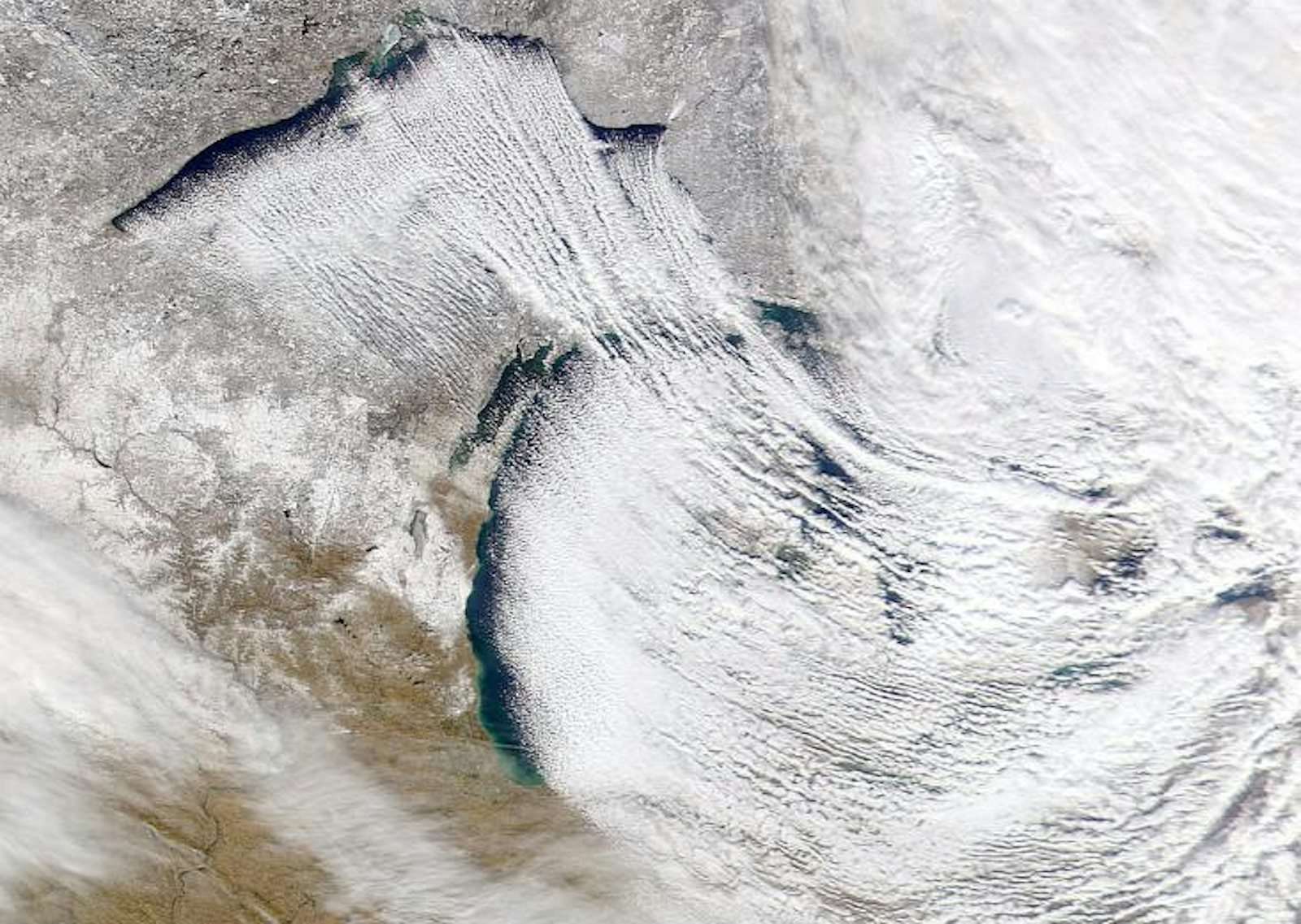
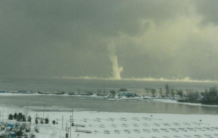
Originating over Lake Ontario, the storm was wreaking havoc on the Tug Hill Plateau, a region in upstate New York. Over the water, the storm formed a number of snownadoes—whitish columns of swirling air stretched between the lake’s surface and the sky. When the storm reached land, it dropped three to four feet of snow on the Tug Hill.
The locals had seen worse—a series of storms over a 10-day period in 2007 dropped almost 12 feet of snow on Redfield, a tiny town on the Tug Hill, and occasionally they come with lightning and thunder. Steiger, who grew up on the snowy streets of Rochester, New York, has been interested in snowstorms since childhood. He used to curse the bands of clouds that would stream off Lake Ontario and bury his house in snow but miss the elementary school 10 miles away. “I would always get annoyed, because I’d still have to go to school,” he says. These narrow but intense bands of snow precipitation are called lake-effect snowstorms. When he grew up, Steiger decided to study the phenomenon.
Similar snowstorms happen in a handful of other places on earth with comparable climate conditions. The Great Salt Lake in Utah produces lake-effect snow as do the Finger Lakes, just a few dozen miles south and southeast of Rochester. Delaware Bay can generate bay-effect snow. The Atlantic Ocean has spawned ocean-effect snowstorms over Boston, Ireland, and even Florida. In February 2005, northeasterly winds off the Black Sea generated a sea-effect storm that dropped more than a foot of snow on Istanbul, Turkey. Just two months ago, the Mediterranean Sea generated a historic sea-effect storm that dropped more than a foot and a half of snow on Jerusalem and even dusted the streets of Cairo. But the most extreme sea-snow effect on earth is produced by the Sea of Japan. Cities located on the northern tip of Japan, such as Kashiwazaki, Myoko, and Aomori, get record-breaking snowfall—Aomori scores 273 inches a year. (On comparison, Syracuse, which is considered to be the U.S.’s snowiest major city, averages about 116 inches a year.) “If you don’t climb up to your roof and take care of your snow,” says Dai Yamamoto, a Colgate University geographer who grew up in snowy Kashiwazaki City, “your house will collapse.”
These powerful storms result from a series of mergers governed by Mother Nature. One of them is converging geographical conditions: The storms can develop only when the cold Arctic air reaches far enough south to pass over a warm body of water. The most intense lake-effect snowstorms happen in middle-latitude locations which stay warm for most of the year and then get cold quickly—such as Japan and the Great Lakes region.
Another merger is that of the actual air currents: Cold air moving over warmer water draws up heat and water vapor. As the warm, moist air rises off the lake, it cools; water condenses into droplets and forms clouds. Winds that blow across the body of water carry the cloud bands towards land, where snow falls. Lake-effect snowstorms are most common in autumn and early winter, when bodies of water are still relatively warm from summer; once they cool or freeze over, the storms’ intensity diminishes. In the Great Lakes region, Lake Ontario produces the largest lake-effect snowstorms, partly because it’s deep and slow to freeze. The city of Aomori owes its epic snow to the cold Siberian winds that blow over the large and warm Sea of Japan. Frigid bodies of water in polar or sub-polar climates, such as Canada’s Hudson Bay or Russia’s Barents Sea, don’t produce much lake- or sea-effect snow.
Snownadoes, also called winter waterspouts, are another type of air merger. When a lake is much warmer than the air above it, trails of steam sometimes waft upward, much like steam coming from a hot cup of coffee. On windy days, this Arctic sea smoke (which is not smoke at all) sometimes forms swirls called steam devils. When the air rises high enough, the moisture in it condenses and forms clouds. If the connection between the lake water and the cloud is made, steam devils becomes winter waterspouts—wispy funnel clouds that swirl out of the sky like swaying soda straws. Snownadoes can be several thousand feet high and stretch from a few feet to a few hundred feet wide. Most of them lose their energy and dissipate when they hit land, but some can cause significant damage, tossing around boats and the like. Snownadoes occur over mid-to-high latitudes, such as the Arctic Ocean, Great Lakes, Caspian Sea, Black Sea, and Sea of Japan.
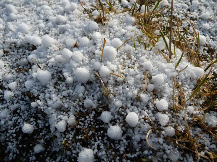
Thunder and lightning, which often accompany lake-effect snowstorms, owe their existence to graupel, an unusual combination of water, snow, and ice. Graupel forms when supercooled water droplets freeze to the sides of falling snowflakes. The flakes lose their shape and turn into dense, bullet-like pellets. These particles rifle through the air, tearing apart other snowflakes and electrically charging them in the process. The taller the clouds, the stronger are the updrafts that pull particles upwards, giving them more time to smash into each other and build up charge. Areas of positive and negative charge form within a cloud, and eventually a bolt of lightning appears, relieving the charge imbalance.
The OWLeS project aims to understand the innards of the lake-effect snowstorms in order to make better predictions. By comparing snowfall reports on the ground to storms’ vitals gathered by King Air, weather balloons, and the Doppler-on-wheels, researchers will be able to build a key for snowstorms’ meteorological signatures. “We are trying to better understand it so we can better predict it and better help people prepare for it,” Steiger says. This is especially important in the era of climate change because global warming may intensify the storms by increasing the temperature difference between the lake and the air. “Lakes will get warmer,” says Colgate University climatologist Adam Burnett. “As long as cold air continues to come across the lake, that could set up an opportunity for more extreme lake-effect snowfall.”
Steiger’s work will help predict weather better not only near the Great Lakes, but in other places where air moves from water to land, like the East Coast, which is periodically brought to a standstill by “nor’easter” storms pulling moisture from the Atlantic. “We have a pretty good understanding of how those systems work but we still have a long way to go,” he says. “We are kind of like Christopher Columbus discovering the new world.”
Justin Nobel’s stories about science and culture have appeared in TIME, Orion, and Tin House. Among other current projects, he is working on a book of tales about the weather. He lives in New Orleans.