

A question hangs like a cloud over the deeply weird winter: Why? What might explain the bizarre warmth of western North America, while the east was buried in a slow-motion avalanche?
Nobody knows for sure, but there’s a very plausible link to climate change. A fast-warming Arctic could alter the jet stream, the vast river of air that flows from west to east around the Northern Hemisphere and drives many of our weather patterns.
Caveats apply, of course. Earth’s systems are too fabulously complex to conclusively link a single event to climate change, and research connecting winter weather to warming-induced jet stream fluctuation is still young. That said, “this is exactly the kind of pattern we expect to see more often,” says Jennifer Francis, a Rutgers University climatologist and leading proponent of what’s known as the “warm Arctic, cold continent” hypothesis—though it might better be called, weird continent.
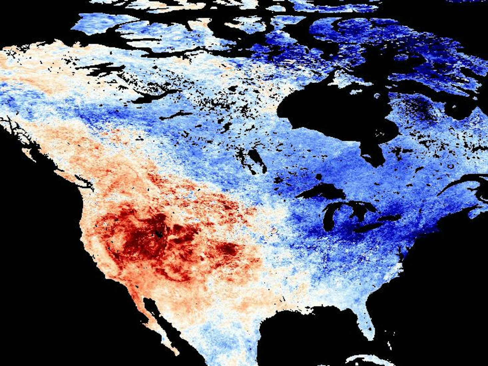
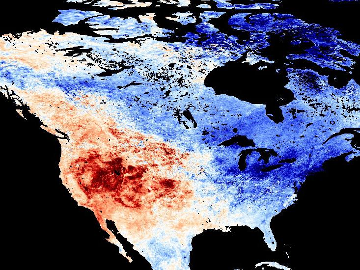
For the second straight year, California experienced its driest January in recorded history. In San Francisco, not a single raindrop fell in what is usually the city’s wettest month. The East Coast was California’s bizarro-world opposite, with the North swamped by marathon snowfall and the typically balmy Southeast going frigid.
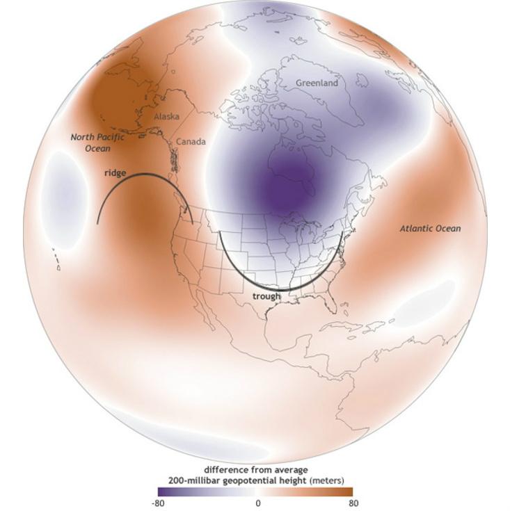
Stretching on through February, the strangeness lent itself to weather graphics: temperature anomaly maps depicting a nation split between bright orange and deep blue. Weather analysts explained this split as consequences of a major fluctuation in the jet stream’s usual, roughly circular path: Over the Pacific and West Coast it grew a “ridge” that humped up northward, all the way to Alaska, even, while a “trough” sagged south over the continental U.S. These big loops let hot, southern air balloon into the west, and then brought a delivery of Arctic air for the east.
Again and again in these explanations, a certain term pops up: The weather lingers. It doesn’t move on. That’s the difference between a dry spell and a drought, a cold snap and a deep freeze. And the jet stream may linger because climate change has for the moment slowed it down.
It’s a notion so vast in scale it’s difficult to imagine, yet the mechanics are fairly simple. The jet stream is generated by a combination of Earth’s rotation and the flow of air down atmospheric gradients between high-pressure, mid-latitude warmth and low-pressure Arctic cold. Over the last several decades, the Arctic has warmed faster than any other region; during periods of especially heightened warming, as occurs when melting sea ice exposes dark, sunlight-absorbing waters, the north-to-south temperature difference shrinks. The pressure differences flatten.
This decreased gradient slows down the jet stream—and as it slows, it also seems to become wavier, plunging south or veering north when encountering atmospheric obstacles it would once have coursed straight through. “The best analogy is to think of a river. When it’s flowing down a steep mountainside, it flows fast and straight,” says Francis. “When it gets to the coastal plain where there’s little slope to the land, it flows slowly and is easily deflected from its path.”
Immediately preceding this episode of jet-stream weirdness, notes Francis, were exceptionally low sea-ice levels in the Pacific Ocean above eastern Siberia and northern Japan. A warming trend there could influence the jet stream over North America. Enter the winter weirdness.
Or so, at least, the hypothesis goes. Other scientists have also linked Arctic temperature changes to lower-latitude weather, but much of that research involved sea-ice loss to the west, in the Barents and Kara Seas, north of the middle of Russia. Ice loss there may indeed lead to colder Eurasian winters, but a similar connection has yet to be empirically established for Pacific ice loss and North American winters.
“The best analogy is to think of a river. When it’s flowing down a steep mountainside, it flows fast and straight. When it gets to the coastal plain where there’s little slope to the land, it flows slowly and is easily deflected from its path.”
“There might be a link,” says Judah Cohen, director of seasonal forecasting at Atmospheric and Environmental Research, a weather-risk-management company, “but that’s much more of an open question. We have firmer ground to stand on with the Barents and Kara Sea ice signal [causing colder winters in Eurasia].”
Cohen, who is particularly interested in mid-latitude effects of Siberian snowfall in October, recently co-authored with Francis a research review of connections between Arctic and mid-latitude weather. A great deal remains to be learned, they say, including such elemental facts as how best to quantify changes in the jet stream—which was, for all its profound importance to Earth’s climate, discovered less than a century ago, and has only been closely studied in recent decades.
Some scientists have also pushed back against these Arctic explanations. In a high-profile letter published last year, several climatologists argued that enthusiasm had outpaced the science itself. Others have argued that the links are not strong, and that apparent jet stream changes are actually artifacts of measurement techniques.
Those researchers have pointed to other climate phenomena, such as cyclical, large-scale shifts in Pacific surface temperatures elsewhere, as more likely explanations for strange winter weather. One such shift occurred just last winter.
That’s possible, admits Francis, though it’s also possible that both factors—global warming’s changes in the Arctic and natural, lower-latitude Pacific temperature shifts—combine to slow the jet stream. “We’ve never been in a situation before where this [cyclical] pattern in the Pacific entered a new phase while there was so much less Arctic ice,” Francis says. “That’s one big question: How is it playing the game in a world with less ice?”
Brandon Keim is a freelance journalist who writes about science, technology, and nature. His work has appeared in Wired, Aeon, Scientific American Mind, and other publications.